Checked content

File:World 1898 empires colonies territory.png

Contents

Summary

Español

*    Gran Bretaña
*    Francia
*    España
*    Portugal
*    Japón
*    Dinastía Qing
*    Austro-Hungría
*    Imperio Otomano
*    Dinamarca
*    Suecia-Noruega
*    Estados Unidos
*    Italia
*    Independiente/otros países

English

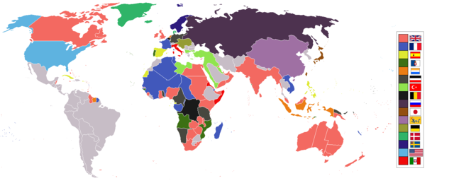
World empires and colonies 1898, (just before the Spanish-American War, Boxer Rebellion and Boer War), derived from Image:BlankMap-World-WWI.PNG

   Britain
   French
   Spain
   Portugal
   Japan
   Qing Empire
   Austro-Hungary
   Ottoman Empire
   Denmark
   Sweden-Norway
   USA
   Italy
   Independent/other countries

Tiếng Việt

   Anh
   Pháp
   Tây Ban Nha
   Bồ Đào Nha
   Nhật Bản
   Nhà Thanh
   Liên quân Áo - Hung
   Đế quốc Ottoman
   Đan Mạch
   Liên quân Thụy Điển - Na Uy
   Hoa Kỳ
   Ý
   Các quốc gia độc lập

Français

Empires et colonies du monde 1898, (juste avant la guerre hispano-américaine, la révolte des Boxers et la guerre des Boers, dérivée de Image:BlankMap-World-WWI.PNG).

   Royaume-Uni
   France
   Espagne
   Portugal
   Pays-Bas
   Allemagne
   Turquie
   Belgique
   Russie
   Japon
   Empire Qing
   Autriche-Hongrie
   Danemark
   Suède-Norvège
   Etats-Unis
   Italie
   Indépendant/d'autres pays

عربي

العربية: خريطة لأمبراطوريات العالم في عام 1898, و هي الفترة التي سبقت عدة حروب, منها الحرب الأمريكية الأسبانية

مستوحاة من Image:BlankMap-World-WWI.PNG

   بريطانيا
   فرنسا
   أسبانيا
   البرتغال
   هولندا
   الرايش الألماني
   العثمانيين
   بلجيكا
   روسيا
   اليابان
   الصين التشينغية
   الإمبراطورية النمساوية المجرية
   الدنمارك
   السويد-النرويج
   الولايات المتحدة الأمريكية
   إيطاليا
   دول أخرى مستقلة

中文

中文: 1898年,世界上的帝國國家與其殖民地(在 美西戰爭、 義和團運動、 布爾戰爭之前)。(模版 Image:BlankMap-World-WWI.PNG)


   大英帝國
   法蘭西第三共和國
   西班牙王國
   葡萄牙王國

{{legend|#eb7d14

   德意志帝國
   鄂圖曼土耳其帝國
   比利時王國
   俄羅斯帝國
   日本帝國
   大清帝國
   奥匈帝國
   丹麥王國
   瑞挪聯盟
   美利堅合眾國
   義大利王國
   其它

Italiano

Italiano: Possedimenti coloniali nel 1898, prima della it:Guerra Ispano-americana, della it:Rivolta dei Boxer e della it:Guerra anglo-boera
   Gran Bretagna
   Francia
   Spagna
   Portogallo
   Olanda
   Germania
   Turchia
   Belgio
   Russia
   Giappone
   Cina
   Austria-Ungheria
   Danimarca
   Svezia-Norvegia
   USA
   Italia
   Altri Paesi

Bahasa Indonesia

Imperium dan koloni di dunia pada tahun 1898 (sebelum Perang Spanyol-Amerika, Pemberontakan Boxer dan Perang Boer).

   Britania Raya
   Perancis
   Spanyol
   Portugal
   Belanda
   Jerman
   Kekaisaran Ottoman, Turki
   Belgia
   Rusia
   Jepang
   Dinasti Qing
   Austria-Hongaria
   Denmark
   Swedia-Norwegia
   Amerika Serikat
   Italia
   Negara merdeka/lainnya

Македонски

Империи и колонии во 1898 г., (веднаш пред Шпанско-американската војна, Боксерското востание и Бурската војна), создадено врз основа на Image:BlankMap-World-WWI.PNG

   Британија
   Франција
   Шпанија
   Португалија
   Холандија
   Германија
   Отоманска
   Белгија
   Русија
   Јапонија
   Кина
   Австроунгарија
   Данска
   Шведска-Норвешка
   САД
   Италија
   Независни/други земји

Nederlands

Wereldrijken en kolonies 1898, (net voor de Spaans-Amerikaanse oorlog, Boxer Rebellie en Boer Oorlog).

   Groot-Britannië
   Frankrijk
   Spanje
   Portugal
   Nederland
   Duitse Rijk
   Ottomaanse Rijk
   België
   Rusland
   Japan
   Qing
   Austro-Hongarije
   Denemarken
   Zweden-Norwegen
   VS
   Italië
   Onafhankelijk/andere landen

Polski

Imperia i kolonie świata w 1898, (przed wojną amerykańsko-hiszpańską, powstaniem bokserów i wojnami burskimi), na podstawie Image:BlankMap-World-WWI.PNG

   Wielka Brytania
   Francja
   Hiszpania
   Portugalia
   Holandia
   Niemcy
   Imperium Osmańskie
   Belgia
   Rosja
   Japonia
   Chiny
   Austro-Węgry
   Dania
   Szwecja-Norwegia
   Stany Zjednoczone
   Włochy
   niepodległe/kolonie innych krajów

Português

   Inglaterra
   França
   Espanha
   Portugal
   Holanda
   Alemanha
   Império Otomano
   Bélgica
   Rússia
   Japão
   Dinastia Qing
   Austro-Hungria
   Dinamarca
   Suécia e Noruega
   EUA
   Itália
   Independentes/Outros Países

Русский

   Великобритания
   Франция
   Испания
   Португалия
   Нидерланды
   Германия
   Османская империя
   Бельгия
   Россия
   Япония
   Китай
   Австро-Венгрия
   Дания
   Швеция и Норвегия
   США
   Италия
   Другие независимые государства

Українська

   Великобританія
   Франція
   Іспанія
   Португалія
   Нідерланди
   Німеччина
   Османська імперія
   Бельгія
   Росія
   Японія
   Китай
   Австро-Угорщина
   Данія
   Шведсько-Норвезька унія
   США
   Італія
   Колонії інших країн та незалежні держави


한국어

1898년 세계의 각 제국과 국가들을 나타낸 지도이다. ( 미국-스페인 전쟁, 의화단 운동, 보어 전쟁 전의 상황이다.)

   영국
   프랑스
   스페인
   포르투갈
   네덜란드
   독일
   오스만 제국 (터키)
   벨기에
   러시아 제국
   일본
   청나라 (중국)
   오스트리아-헝가리
   덴마크
   스웨덴-노르웨이
   미국
   이탈리아
   독립국/다른 나라

日本語

   イギリス
   フランス
   スペイン
   ポルトガル
   オランダ
   ドイツ
   トルコ
   ベルギー
   ロシア
   日本
   清国
   ハンガリー
   デンマーク
   スウェーデン
   アメリカ合衆国
   イタリア
   その他の独立国

עברית

Template:Legends as

   צרפת
   ספרד
   פורטוגל
   יפן
   אוסטרו-הונגריה
   דנמרק
   שוודיה-נורווגיה
   ארה"ב
   איטליה
   מדינות עצמאיות/אחר

gurupletos

See also


Maps of world history
BC

2000 · 1000 · 500 · 400 · 323 · 300 · 200 · 100 · 50


AD

1 · 50 · 100 · 200 · 250 · 300 · 400 · 500 · 700 · 750 · 820 · 900 · 1959 · 1980 ·


Maps of colonization history
1492 · 1550 · 1660 · 1754 · 1800 · 1822 · 1885 · 1898 · 1914 · 1920 · 1936 · 1938 · 1945 · 1959 · 1974 · 2007

see also: Eastern Hemisphere only maps template (1300BC-1500AD)

(this template: · view · discuss )

Licensing

I, the copyright holder of this work, hereby publish it under the following licenses:
GNU head Permission is granted to copy, distribute and/or modify this document under the terms of the GNU Free Documentation License, Version 1.2 or any later version published by the Free Software Foundation; with no Invariant Sections, no Front-Cover Texts, and no Back-Cover Texts. A copy of the license is included in the section entitled GNU Free Documentation License.

w:en:Creative Commons
attribution share alike
This file is licensed under the Creative Commons Attribution-Share Alike 3.0 Unported license.
You are free:
  • to share – to copy, distribute and transmit the work
  • to remix – to adapt the work
Under the following conditions:
  • attribution – You must attribute the work in the manner specified by the author or licensor (but not in any way that suggests that they endorse you or your use of the work).
  • share alike – If you alter, transform, or build upon this work, you may distribute the resulting work only under the same or similar license to this one.
This licensing tag was added to this file as part of the GFDL licensing update.

You may select the license of your choice.
Converted to SVG.svg This map image could be recreated using vector graphics as an SVG file. This has several advantages; see Commons:Media for cleanup for more information. If an SVG form of this image is already available, please upload it. After uploading an SVG, replace this template with {{ vector version available|new image name.svg}}.
Annotations This image is annotated: View the annotations at Commons
The following pages on Schools Wikipedia link to this image (list may be incomplete):

Metadata

A background to Schools Wikipedia

You can learn about nearly 6,000 different topics on Schools Wikipedia. By supporting vulnerable children right through to adulthood, SOS Childrens Villages makes a lasting difference to the lives of thousands of people. Education is a key part of our work, and our schools provide high-quality teaching to the children in our care. Go to http://www.soschildrensvillages.org.uk/sponsor-a-child to sponsor a child.