 |
This is a file from the Wikimedia Commons. Information from its description page there is shown below.
Commons is a freely licensed media file repository. You can help.
|
Summary
| DescriptionWest-turkey-plates-cropped.gif |
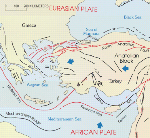
English: The tectonic map of Turkey includes the North Anatolian fault, East Anatolian fault, and Hellenic and Florence trenches. The westward movement of the Anatolian block results from (1) differences in rates of motion between the Arabian and African plates, (2) different directions of motion between the Anatolian block and Eurasian plate to the north, and (3) subduction of the African plate beneath the Anatolian block at the Hellenic and Florence trenches. The Arabian plate is moving to the north faster than the African plate, both relative to a stable Eurasian plate. The result is a westward moving wedge incorporating most of Turkey.
|
| Date |
22 November 1999 |
| Source |
http://neic.usgs.gov/neis/eq_depot/2003/eq_030501/neic_tgac_maps.html |
| Author |
U.S. Geological Survey |
Licensing
| Public domainPublic domainfalsefalse |
 |
This image is in the public domain because it contains materials that originally came from the United States Geological Survey, an agency of the United States Department of the Interior. For more information, see the official USGS copyright policy.
български | català | Deutsch | English | español | eesti | suomi | français | galego | italiano | 한국어 | македонски | മലയാളം | Nederlands | polski | português | русский | Türkçe | 中文 | 中文(简体) | +/−
|
|
File usage
The following pages on Schools Wikipedia link to this image (list may be incomplete):
SOS Children chose the best bits of Wikipedia to help you learn. SOS Childrens Villages believes education is an important part of a child's life. That's why we ensure they receive nursery care as well as high-quality primary and secondary education. When they leave school, we support the children in our care as they progress to vocational training or higher education. Will you help another child today?


