
File:Katyn a.png
Size of this preview: 412 × 479 pixels.
| |
This is a file from the Wikimedia Commons. Information from its description page there is shown below.
Commons is a freely licensed media file repository. You can help. |
| Description |
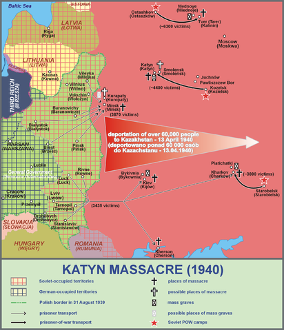
Polski: Zbrodnia katyńska (1940)
English: Map of the Massacre of Katyn
|
| Date | 18 March 2012 |
| Source | Instytut Pamięci Narodowej (Polska) - Katyń 1940 - Geografia zbrodni (aktualizacja 13.04.2012) |
| Author | Lonio17 |
Licensing
|

File usage
The following pages on Schools Wikipedia link to this image (list may be incomplete):
Metadata
What is Schools Wikipedia?
Wikipedia for Schools brings Wikipedia into the classroom. Our 500 Children's Villages provide a home for thousands of vulnerable children. Beyond our Villages, we support communities, helping local people establish better schools and delivering effective medical care to vulnerable children. If you'd like to help, learn how to sponsor a child.