File:Kiev on 1804 map.jpg
Kiev_on_1804_map.jpg (272 × 208 pixels, file size: 21 KB, MIME type: image/jpeg)
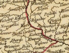
- A fragment of the old map.
- Original full title of the map: A new map of Europe, from the latest authorities. By John Cary, engraver, 1804. London: Published by J. Cary, Engraver & Map-seller, No. 181, Strand, Novr. 28, 1804.
- Author: Cary, John, ca. 1754-1835
- Date: 1804
- Publisher: London: John Cary.
- Scale 1: 11,000,000
- Pub Date: 1808
- Pub Title: Cary's new universal atlas, containing distinct maps of all the principal states and kingdoms throughout the World. From the latest and best authorities extant. London: Printed for J. Cary, Engraver and Map-seller, No. 181, near Norfolk Street, Strand, 1808.
- Full map: Image:Europe_map_1804_Cary.jpg
- File cropped from the source obtained at David Rumsey Map Collection ( http://www.davidrumsey.com/detail?id=1-1-21497-630111&name=Europe.)
 |
This file is in the public domain because its copyright has expired in the United States and those countries with a copyright term of no more than the life of the author plus 100 years. |
| The uploader or another editor requests that the local copy of this file be kept. This image or media file may be available on the Wikimedia Commons as File:Kiev on 1804 map.jpg. While the license of this work may be compliant with the Wikimedia Commons, an editor has requested that the local copy be kept too. This file does not meet CSD F8, and should not be nominated for deletion as a Commons duplicate without the permission of the tagging editor. |
|
File usage
The following pages on Schools Wikipedia link to this image (list may be incomplete):
Background information
All five editions of Schools Wikipedia were compiled by SOS Children's Villages. The world's largest orphan charity, SOS Children's Villages brings a better life to more than 2 million people in 133 countries around the globe. Find out more about sponsoring a child.
Categories:

