
File:Gaur map.png
Gaur_map.png (334 × 269 pixels, file size: 10 KB, MIME type: image/png)
| |
This is a file from the Wikimedia Commons. Information from its description page there is shown below.
Commons is a freely licensed media file repository. You can help. |
Summary
| Description |
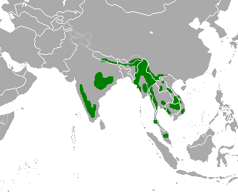
English: Range map of gaur (Bos gaurus) according to Duckworth, J.W., Steinmetz, R., Timmins, R.J., Pattanavibool, A., Than Zaw, Do Tuoc & Hedges, S. 2008. Bos gaurus. In: IUCN 2011. IUCN Red List of Threatened Species. Version 2011.2.
|
| Date | 4 March 2012 |
| Source | Own work |
| Author | Altaileopard |
Licensing
|
File usage
The following pages on Schools Wikipedia link to this image (list may be incomplete):
Metadata
Schools Wikipedia facts
This selection has made Wikipedia available to all children. By supporting vulnerable children right through to adulthood, SOS Children makes a lasting difference to the lives of thousands of people. Education is a key part of our work, and our schools provide high-quality teaching to the children in our care. Would you like to sponsor a child?