
File:Rheinbund 1812.png
Size of this preview: 408 × 480 pixels.
| |
This is a file from the Wikimedia Commons. Information from its description page there is shown below.
Commons is a freely licensed media file repository. You can help. |
Summary
| Description |
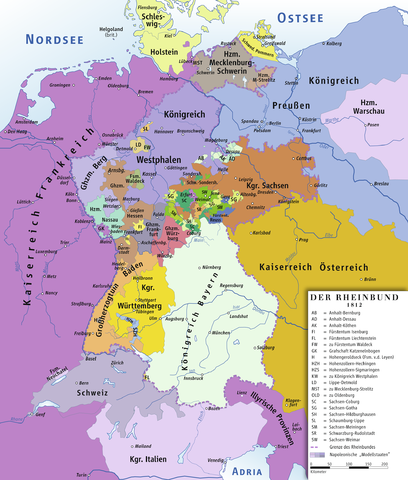
Deutsch: Karte des Rheinbundes 1812
English: Map of Confederation of the Rhine 1812
|
||||||||||||||
| Date | 12 February 2007 | ||||||||||||||
| Source | Own work drawing/Source of Information: Putzger – Historischer Weltatlas, 89. Auflage, 1965; Westermanns Großer Atlas zuur Weltgeschichte, 1969; Haacks geographischer Atlas. VEB Hermann Haack Geographisch-Kartographische Anstalt, Gotha/Leipzig, 1. Auflage, 1979. | ||||||||||||||
| Author | ziegelbrenner | ||||||||||||||
| Permission ( Reusing this file) |
|

 |
This map image could be recreated using vector graphics as an SVG file. This has several advantages; see Commons:Media for cleanup for more information. If an SVG form of this image is already available, please upload it. After uploading an SVG, replace this template with {{ vector version available|new image name.svg}}. |
File usage
The following pages on Schools Wikipedia link to this image (list may be incomplete):
Find out about Schools Wikipedia
SOS Children aims to make Wikipedia suitable for young learners. SOS Children's Villages is there for the children in our care until they are ready for independence. Sponsoring a child is the coolest way to help.