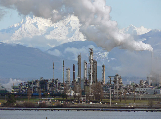
File:Anacortes Refinery 31911.JPG

| |
This is a file from the Wikimedia Commons. Information from its description page there is shown below.
Commons is a freely licensed media file repository. You can help. |
| Description |
English: Oil refinery#Anacortes Refinery (Tesoro Corporation), on the north end of March Point; Mount Baker (10,781 feet, 3286 meters); 2006 refinery capacity, 115,000 barrels per day; 917 acres, 350 employees
Français : La Raffinerie d' Anacortes, sur l'extrémité nord de March Point, propriété de la compagnie Tesoro. E arrière plant, le mont Baker (3286 m). En 2006, la rafinerie avait une capcité de traitement de 115 000 barils par jour, une surface de 371 ha, et employait 350 personnes.
|
| Date | 2008:01:13T11:40:35-8.00 |
| Source | Own work |
| Author | Walter Siegmund (talk) |
|
Camera location |
48° 29′ 3.12″ N, 122° 35′ 44.52″ W |
This and other images at their locations on: Google Maps - Google Earth - OpenStreetMap | ( Info)48.4842;-122.5957 |
|---|
- Location Datum: WGS84
- Viewpoint location: Washington State Route 20, Sunrisers Kiwanis Park Anacortes, Washington
- Viewpoint elevation: 80 foot (24 m)
- View direction: East-northeast
- Camera: Panasonic DMC-FZ5
- Exposure Time: 1/800
- F Number: f/4.5
- Focal Length: 62.0
- Focal Length In 35mm Film: 372
- ISO Speed Rating: 80
©2008 Walter Siegmund
Licensing
|
 |
This image has been assessed under the valued image criteria and is considered the most valued image on Commons within the scope: Oil refinery. You can see its nomination at Commons:Valued image candidates/Anacortes Refinery 31911.JPG.
|
 |
This image has been assessed using the Quality image guidelines and is considered a Quality image.
|
File usage
Metadata
| Camera manufacturer | Panasonic |
|---|---|
| Camera model | DMC-FZ5 |
| Exposure time | 1/800 sec (0.00125) |
| F-number | f/4.5 |
| ISO speed rating | 80 |
| Date and time of data generation | 11:40, 13 January 2008 |
| Lens focal length | 62 mm |
| Latitude | 48° 29′ 2.96″ N |
| Longitude | 122° 35′ 44.5″ W |
| Altitude | 0 meters above sea level |
| Orientation | Normal |
| Horizontal resolution | 72 dpi |
| Vertical resolution | 72 dpi |
| Software used | Adobe Photoshop Elements 4.0.1 Macintosh |
| File change date and time | 13:03, 8 November 2010 |
| Y and C positioning | Co-sited |
| Exposure Program | Normal program |
| Exif version | 2.2 |
| Date and time of digitizing | 11:40, 13 January 2008 |
| Meaning of each component |
|
| Image compression mode | 4 |
| Exposure bias | 0 |
| Maximum land aperture | 3 APEX (f/2.83) |
| Metering mode | Pattern |
| Light source | Unknown |
| Flash | Flash did not fire, compulsory flash suppression |
| Supported Flashpix version | 0,100 |
| Colour space | sRGB |
| Sensing method | One-chip colour area sensor |
| File source | Digital still camera |
| Scene type | A directly photographed image |
| Custom image processing | Normal process |
| Exposure mode | Auto exposure |
| White balance | Auto white balance |
| Digital zoom ratio | 0 |
| Focal length in 35 mm film | 372 mm |
| Scene capture type | Standard |
| Scene control | None |
| Contrast | Normal |
| Saturation | Normal |
| Sharpness | Normal |
| Satellites used for measurement | tilt:0.000 |
| Reference for direction of image | True direction |
| Direction of image | 343.74 |
| Reference for distance to destination | Kilometers |
| Distance to destination | 0.06596 |
| GPS tag version | 0.0.2.2 |
| Supported Flashpix version | 1 |
| Image height | 2,527 px |
| Image width | 1,875 px |
| Date metadata was last modified | 05:03, 8 November 2010 |
Wikipedia for Schools...
SOS Childrens Villages aims to make Wikipedia suitable for young learners. Our 500 Children's Villages provide a home for thousands of vulnerable children. Beyond our Villages, we support communities, helping local people establish better schools and delivering effective medical care to vulnerable children. There are many ways to help with SOS Children's Villages.

