
File:Diagram showing historical levels of Lake Superior.jpg
| This image was uploaded in the JPEG format even though it consists of non-photographic data. The information it contains could be stored more efficiently or more accurately in the PNG or SVG format. If possible, please upload a PNG or SVG version of this image, derived from a non-JPEG source so that it doesn't contain any compression artifacts (or with existing artifacts removed) and with transparency where appropriate. After doing so, please replace all instances of the JPEG version throughout Wikipedia (noted under the "File links" header), tag the JPEG version with |
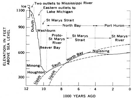
Diagram showing effect of glaciation and post-glaciation unloading on the height of Lake Superior above sea level. From .
 |
This image is a work of a United States Geological Survey employee, taken or made as part of that person's official duties. As a work of the United States Government, the image is in the public domain. For more information, see the USGS copyright policy. See Wikipedia:Public domain and Wikipedia:Copyrights for more details. | |
 |
This is a candidate to be copied to Wikimedia Commons. Freely licensed or public domain media are more accessible to other Wikimedia projects if placed on Commons. Any user may perform this move—please see Moving images to the Commons for more information. Please thoroughly review the copyright status of this file and ensure that it is actually eligible for transfer to Commons. If you are concerned that this file could have problems with its attribution information and/or copyright status, then remove this notice and DO NOT transfer it to Commons. By transferring this file to Commons, you acknowledge you have read this message and are willing to accept any and all consequences for inappropriate transfers. Repeat violators will be blocked from editing. If you have checked the file and it is OK to move to Commons add "|human=username" to the template so other users can see it has been checked and can help you copy the file to Commons. If the file can't be moved to Commons consider nominating the file for deletion or changing the template to {{NotMovedToCommons|reason=Why it can't be copied to Commons}} If this image has been copied to Commons replace this tag with {{subst:ncd}} or {{subst:ncd|Image name on Commons.ext}} if a different filename is used on Commons. Copy to Commons: via CommonsHelper |
||
|
|||
File usage
Find out more
All five editions of Schools Wikipedia were compiled by SOS Children. Thanks to SOS Childrens Villages, 62,000 children are enjoying a happy childhood, with a healthy, prosperous future ahead of them. Will you help another child today?