 |
This is a file from the Wikimedia Commons. Information from its description page there is shown below.
Commons is a freely licensed media file repository. You can help.
|
| Description |
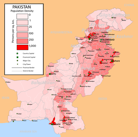
English: Pakistan Population Density Map (English). (Abbreviations used: 1. NWFP = North West Frontier Province, 2. FATA = Federally Administered Tribal Areas.)
|
| Date |
13 August 2009 (first version); 11 June 2009 (last version) |
| Source |
Transferred from en.wikipedia
(Original text : I created this work by myself with the sources of World Trade Press and Population census organisation, Government of Pakistan.) |
| Author |
nomi887 ( talk). Original uploader was Nomi887 at en.wikipedia. Later version(s) were uploaded by Brainlara73 at en.wikipedia. |
Permission
( Reusing this file) |
CC-BY-SA-3.0; Released under the GNU Free Documentation License.
|
Licensing
Nomi887 at en.wikipedia, the copyright holder of this work, hereby publishes it under the following licenses:
 |
Permission is granted to copy, distribute and/or modify this document under the terms of the GNU Free Documentation License, Version 1.2 or any later version published by the Free Software Foundation; with no Invariant Sections, no Front-Cover Texts, and no Back-Cover Texts. A copy of the license is included in the section entitled GNU Free Documentation License. http://www.gnu.org/copyleft/fdl.htmlGFDLGNU Free Documentation Licensetruetrue
|
You may select the license of your choice.
|
File usage
The following pages on Schools Wikipedia link to this image (list may be incomplete):


