 |
This is a file from the Wikimedia Commons. Information from its description page there is shown below.
Commons is a freely licensed media file repository. You can help.
|
Summary
| Description |
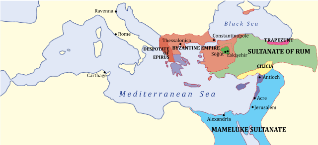
English: Middle East c. 1263. KEY: *Green: Ottoman domain by 1300's, dotted line indicates conquests up to 1326 *Light Red: Byzantine Empire (successor of Nicaean Empire) *Dark Green: Turk lands, nominal vassals of Sultanate of Rum *Light Yellow: Armenian Kingdom of Cilicia *Dark/Light Purple Latin states Category:Maps of the Byzantine Empire
|
| Date |
2011-12-10 17:08 (UTC) |
| Source |
|
| Author |
- derivative work: Hoodinski ( talk)
|
 |
This is a retouched picture, which means that it has been digitally altered from its original version. Modifications: SVG version. The original can be viewed here: 1263_Mediterranean_Sea.PNG. Modifications made by Hoodinski.
|
Licensing
I, the copyright holder of this work, hereby publish it under the following license:
| Public domainPublic domainfalsefalse |
 |
This work has been released into the public domain by its author, Example at the [[:|]] project. This applies worldwide.
In case this is not legally possible:
Example grants anyone the right to use this work for any purpose, without any conditions, unless such conditions are required by law.
|
|
File usage
The following pages on Schools Wikipedia link to this image (list may be incomplete):
This file contains additional information, probably added from the digital camera or scanner used to create or digitize it. If the file has been modified from its original state, some details may not fully reflect the modified file.
SOS Children's Villages aims to make Wikipedia suitable for young learners. SOS Children's Villages helps more than 2 million people across 133 countries around the world. There are many ways to help with SOS Childrens Villages.


