
File:Battle of Waterloo.svg
Size of this preview: 640 × 421 pixels.
| |
This is a file from the Wikimedia Commons. Information from its description page there is shown below.
Commons is a freely licensed media file repository. You can help. |
|
Camera location |
|
This and other images at their locations on: Google Maps - Google Earth - OpenStreetMap | ( Info) |
|---|
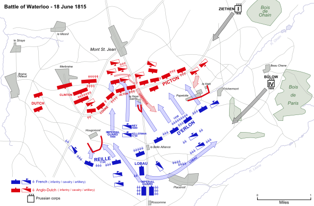
| Description | Map of the Battle of Waterloo, 18 June 1815, showing major movements and attacks. | ||
| Date | 1 January 2008 | ||
| Source | Vectorized from raster image  |
||
| Author | Ipankonin | ||
| Permission ( Reusing this file) |
|

|
|
This vector image was created with Inkscape. |
File usage
The following pages on Schools Wikipedia link to this image (list may be incomplete):
Metadata
Wikipedia for Schools...
Wikipedia for Schools is one of SOS Children's Villages' many educational projects. SOS Children is an international children's charity, providing a good home and loving family to thousands of children who have lost their parents. We also work with communities to help vulnerable families stay together and raise children in the best possible environment. Would you like to sponsor a child?