
File:Bermuda topographic map-en.png
| |
This is a file from the Wikimedia Commons. Information from its description page there is shown below.
Commons is a freely licensed media file repository. You can help. |
Summary
|
Camera location |
|
View this and other nearby images on: Google Maps - Google Earth - OpenStreetMap | ( Info) |
|---|
| Description |
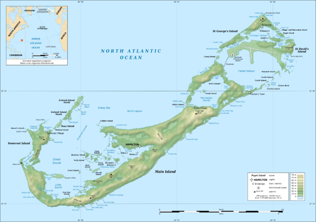
English: Topographic map of Bermuda Islands, Great Britain, in the North Atlantic Ocean.
Note: The background map is a raster image embedded in the SVG file. Français : Carte topographqiue de l' archipel des Bermudes, Grande-Bretagne, dans l'Océan Atlantique Nord.
Note : Le fond de carte est une image bitmap embarquée dans le fichier SVG.
|
||
| Date | April 2009 | ||
| Source | Own work ;
|
||
| Author | Eric Gaba ( Sting - fr:Sting) | ||
| Permission ( Reusing this file) |
|
This map was improved or created by the Wikigraphists of the Graphic Lab (fr). You can propose images to clean up, improve, create or translate as well.
বাংলা | català | česky | Deutsch | Deutsch (Sie-Form) | Ελληνικά | English | Esperanto | español | suomi | français | עברית | magyar | Հայերեն | italiano | 한국어 | македонски | Bahasa Melayu | Plattdüütsch | Nederlands | occitan | polski | português | română | русский | slovenščina | svenska | татарча/tatarça | Türkçe | українська | 中文 | 中文(简体) | 中文(繁體) | Zazaki | +/−
Licensing
|

File usage
I want to learn more...
Wikipedia for Schools was collected by SOS Children's Villages. The world's largest orphan charity, SOS Children's Villages brings a better life to more than 2 million people in 133 countries around the globe. Find out how you can help children in other countries.