
File:Megi 2010-10-18 0235Z.jpg
Size of this preview: 365 × 479 pixels.
| |
This is a file from the Wikimedia Commons. Information from its description page there is shown below.
Commons is a freely licensed media file repository. You can help. |
|
Warning |
Some browsers may have trouble displaying this image at full resolution: This image has a large number of pixels and may either not load properly or cause your browser to freeze. | Interactive large-image-viewer ( non-Flash) |
|---|
Summary
| Description |
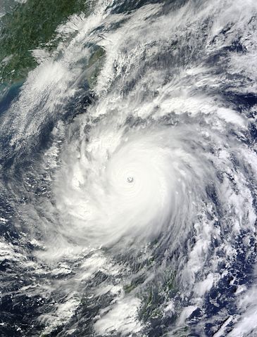
English: On October 18, 2010, Typhoon Megi approached and made landfall in the northeastern Isabela Province of the Philippines. Spanning more than 600 kilometers (370 miles) across, it was the most intense tropical cyclone of the year to date.
This image was taken by the Moderate Resolution Imaging Spectroradiometer (MODIS) on NASA’s Terra satellite at 10:35 a.m. Philippine Time (02:35 UTC) on October 18, 2010. The official international name of the storm is Megi, which means “catfish” in Korean. But the storm is known locally as Juan, as the Philippine Atmospheric, Geophysical and Astronomical Services Administration has its own naming system. |
| Date | 18 October 2010 |
| Source | http://earthobservatory.nasa.gov/NaturalHazards/view.php?id=46425 |
| Author | NASA image by Jeff Schmaltz, MODIS Rapid Response Team, Goddard Space Flight Centre |
|
Camera location |
|
This and other images at their locations on: Google Maps - Google Earth - OpenStreetMap | ( Info) |
|---|
Licensing
 |
This file is in the public domain because it was solely created by NASA. NASA copyright policy states that "NASA material is not protected by copyright unless noted". (See Template:PD-USGov, NASA copyright policy page or JPL Image Use Policy.) |
 |
 |
Warnings:
|
File usage
The following pages on Schools Wikipedia link to this image (list may be incomplete):
Metadata
The best way to learn
SOS Childrens Villages has brought Wikipedia to the classroom. SOS Childrens Villages cares for children who have lost their parents. Our Children's Villages give these children a new home and a new family, while a high-quality education and the best of medical care ensures they will grow up with all they need to succeed in adult life. Have you thought about sponsoring a child?