 |
This is a file from the Wikimedia Commons. Information from its description page there is shown below.
Commons is a freely licensed media file repository. You can help.
|
Summary
| DescriptionNS administrative Gliederung 1944.png |
Беларуская (тарашкевіца): Мапа адміністрацыйна-тэрытарыяльнага падзелу Вялікага нямецкага райху паводле НСДАП (1944).
Мапа ў высокім разрозьненьні: http://upload.wikimedia.org/wikipedia/commons/archive/8/83/20100818145815%21NS_administrative_Gliederung_1944.png
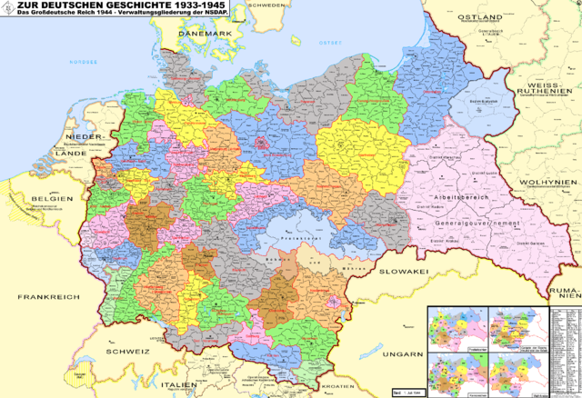
Deutsch: Karte der administrativen Gliederung des Großdeutschen Reiches durch die NSDAP 1944. Sie zeigt die Kreise, Gaue und Reichsgaue der NSDAP. Zudem Postleitzahlen, Kennzeichen, Wehrkreise und Arbeitsamtsgebiete 1944.
English: Map of the administrative division of the Greater German Reich (»Großdeutsches Reich«/»Großdeutschland«/"Greater German Empire"/"Greater Germany") by the NSDAP 1944, showing Kreise, Gaue and Reichsgaue. Also postalcodes, licenseplates, military districts and workingcoordination areas 1944.
High resolution image: http://upload.wikimedia.org/wikipedia/commons/archive/8/83/20100818145815%21NS_administrative_Gliederung_1944.png
Polski: Mapa Wielkiej Rzeszy Niemieckiej (1944)
Русский: Административно-территориальное деление Третьего Рейха - Великой Германии (1944)
Українська: Адміністративно-територіальний поділ Третього Рейху - Великої Німеччини (1944)
|
| Date |
18 August 2010 |
| Source |
Own work |
| Author |
Exec |
 |
This map image could be recreated using vector graphics as an SVG file. This has several advantages; see Commons:Media for cleanup for more information. If an SVG form of this image is already available, please upload it. After uploading an SVG, replace this template with {{ vector version available|new image name.svg}}. |
Licensing
I, the copyright holder of this work, hereby publish it under the following licenses:
 |
Permission is granted to copy, distribute and/or modify this document under the terms of the GNU Free Documentation License, Version 1.2 or any later version published by the Free Software Foundation; with no Invariant Sections, no Front-Cover Texts, and no Back-Cover Texts. A copy of the license is included in the section entitled GNU Free Documentation License. http://www.gnu.org/copyleft/fdl.htmlGFDLGNU Free Documentation Licensetruetrue
|
You may select the license of your choice.
|
File usage
The following pages on Schools Wikipedia link to this image (list may be incomplete):
SOS Children aims to make Wikipedia suitable for young learners. SOS Childrens Villages is there for the children in our care until they are ready for independence. There are many ways to help with SOS Children.


