
File:Geomorphology of Old River.jpg
Size of this preview: 543 × 480 pixels.
| |
This is a file from the Wikimedia Commons. Information from its description page there is shown below.
Commons is a freely licensed media file repository. You can help. |
Summary
| Description |
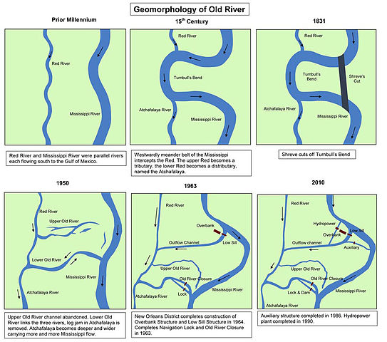
English: Maps showing the history of the course of the Mississippi river at what is now the Old River Control Structure in Louisiana.
|
| Date | 2011 |
| Source | http://www.mvs.usace.army.mil/arec/models_old_html.html |
| Author | United States Army Corps of Engineers |
Licensing
 |
This image is a work of a U.S. Army soldier or employee, taken or made as part of that person's official duties. As a work of the U.S. federal government, the image is in the public domain.
|
 |
File usage
The following pages on Schools Wikipedia link to this image (list may be incomplete):
I want to learn more...
SOS Children's Villages chose the best bits of Wikipedia to help you learn. SOS Childrens Villages works in 133 countries and territories across the globe, helps more than 62,000 children, and reaches over 2 million people in total. Would you like to sponsor a child?