
File:Mississippi River Lock and Dam number 15.jpg
Size of this preview: 640 × 427 pixels.
| |
This is a file from the Wikimedia Commons. Information from its description page there is shown below.
Commons is a freely licensed media file repository. You can help. |
|
This is an image of a place or building that is listed on the National Register of Historic Places in the United States. Its reference number is 4000175. |
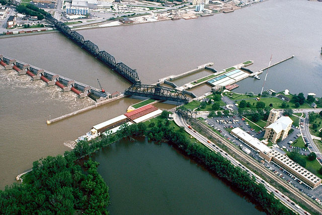
| Description | Aerial view of Lock and Dam No. 15 on the Mississippi River between Rock Island, Illinois and Davenport, Iowa. View is from the Illinois side of the river looking northwest to Iowa. The Government Bridge, a combined auto and railroad bridge, spans the river right over the locks, necessitating a turntable drawbridge to clear the locks. Rock Island District Office is also located here. Location: Rock Island, Illinois, 41°31′07″N 90°34′08″W / 41.51861°N 90.56889°W |
|||
| Date | 1 September 1990 | |||
| Source | US Army Corps of Engineers Digital Visual Library (DVL) Image description |
|||
| Author | US Army Corps of Engineers, Carol Arney | |||
| Permission ( Reusing this file) |
|

|
Object location |
|
This and other images at their locations on: Google Maps - Google Earth - OpenStreetMap - Proximityrama | ( Info) |
|---|
File usage
The following pages on Schools Wikipedia link to this image (list may be incomplete):
Metadata
What is Schools Wikipedia?
Wikipedia for Schools is one of SOS Childrens Villages' many educational projects. SOS Childrens Villages helps those who have nothing and no one, giving them back the famly they have lost and bringing them the very best opportunities for a happy, healthy future. You can help by sponsoring a child.