 |
This is a file from the Wikimedia Commons. Information from its description page there is shown below.
Commons is a freely licensed media file repository. You can help.
|
Summary
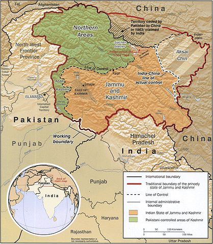
The disputed area of Kashmir.
 |
This map is available from the United States Library of Congress's Geography & Map Division under the digital ID g7653j.ct000803.
This tag does not indicate the copyright status of the attached work. A normal copyright tag is still required. See Commons:Licensing for more information.
|
CREATED/PUBLISHED
[Washington : Central Intelligence Agency, 2002]
NOTES
"760279AI (R00744) 6-02."
Relief shown by shading.
Includes location map.
MEDIUM
1 map : col. ; 20 x 17 cm.
CALL NUMBER
G7653.J3F2 2002 .U5
CONTROL NUMBER
2002626371
REPOSITORY
Library of Congress Geography and Map Division Washington, D.C. 20540-4650 USA
DIGITAL ID
g7653j ct000803  http://hdl.loc.gov/loc.gmd/g7653j.ct000803
Licensing
| Public domainPublic domainfalsefalse |
 |
This image is a work of a Central Intelligence Agency employee, taken or made as part of that person's official duties. As a Work of the United States Government, this image or media is in the public domain.
|
 |
Old file history
taken from de.wiki there under PD with description
File usage
The following pages on Schools Wikipedia link to this image (list may be incomplete):
Through Schools Wikipedia, SOS Children's Villages has brought learning to children around the world. SOS Childrens Villages believes that a decent childhood is essential to a happy, healthy. Our community work brings families new opportunities through education, healthcare and all manner of support. If you'd like to help, learn how to sponsor a child.


