File:India-map-en.png
- File
- File usage
- Did you know...?

Size of this preview: 411 × 480 pixels.
| |
This is a file from the Wikimedia Commons. Information from its description page there is shown below.
Commons is a freely licensed media file repository. You can help. |
 |
File:India-map-en.svg is a vector version of this file. It should be used in place of this raster image when superior. File:India-map-en.png
For more information about vector graphics, read about Commons transition to SVG.
|
 |
Summary
| Description |
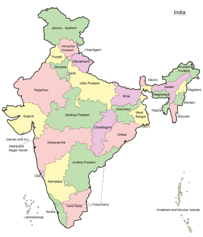
മലയാളം: ഇന്ത്യയുടെ ഭൂപടം - സംസ്ഥാനങ്ങളും കേന്ദ്രഭരണപ്രദേശങ്ങളും അടയാളപ്പെടുത്തിയിരിക്കുന്നു - ഇംഗ്ലീഷ്, പിഎൻ.ജി ഫോർമാറ്റ്
|
| Date | 10 April 2011 |
| Source | Transferred from ml.wikipedia by Sreejith K ( talk) |
| Author | Original uploaded by Rajeshodayanchal. |
Licensing
| This media file is uploaded with Malayalam loves Wikimedia event. English | हिन्दी | italiano | македонски | മലയാളം | Deutsch | Nederlands | +/− |
|
Did you know...?
Wikipedia for Schools was collected by SOS Children. SOS Children's Villages helps more than 2 million people across 133 countries around the world. If you'd like to help, learn how to sponsor a child.
