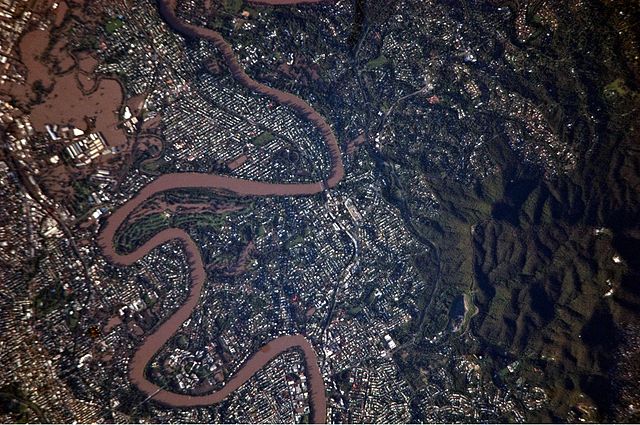
File:2011 Flooding in Brisbane Suburbs.JPG

Size of this preview: 640 × 425 pixels.
| |
This is a file from the Wikimedia Commons. Information from its description page there is shown below.
Commons is a freely licensed media file repository. You can help. |
Summary
| Description2011 Flooding in Brisbane Suburbs.JPG |
English: This detailed satellite photograph illustrates flooding in metropolitan suburbs of the Brisbane, Queensland, Australia. Please note that the top of the photo is oriented approximately to the South-West and not to the North. The image, taken by astronauts on board the International Space Station, highlights several suburbs along the Brisbane River in the southern part of the Brisbane metropolitan area. The light-coloured rooftops of residences and other structures contrast sharply with green vegetation and brown, sediment laden flood-waters. Most visible low-lying areas are inundated by flood-water, perhaps the most striking being Rocklea at image upper left. The suburb of Yeronga (image lower left) also has evident regions of flooding, as does a park and golf course located along a bend in the Brisbane River to the south of St. Lucia (image centre). Flooding becomes less apparent near the higher elevations of Mt. Coot-Tha at image right.
|
| Date | 13 January 2011 |
| Source | NASA Earth Observatory |
| Author | ISS Expedition 26 crew |
|
Camera location |
27° 30′ 0.00″ S, 153° 0′ 0.00″ E |
View this and other nearby images on: Google Maps - Google Earth - OpenStreetMap | ( Info)-27.5;153 |
|---|
| This image or video was catalogued by Johnson Space Centre of the United States National Aeronautics and Space Administration (NASA) under Photo ID: ISS026-E-17421. This tag does not indicate the copyright status of the attached work. A normal copyright tag is still required. See Commons:Licensing for more information. |
Image acquired with a Nikon D2Xs digital camera using an 800 mm lens, and is provided by the ISS Crew Earth Observations experiment and Image Science & Analysis Laboratory, Johnson Space Centre.
Licensing
| Public domainPublic domainfalsefalse |
 |
This file is in the public domain because it was solely created by NASA. NASA copyright policy states that "NASA material is not protected by copyright unless noted". (See Template:PD-USGov, NASA copyright policy page or JPL Image Use Policy.) |
 |
 |
Warnings:
|
| Annotations | This image is annotated: View the annotations at Commons |
434
643
139
123
4288
2850
Rocklea
750
964
247
96
4288
2850
flooding
1887
364
263
177
4288
2850
flooding
1099
1173
220
64
4288
2850
Brisbane River
2235
1516
209
188
4288
2850
Taringa
3709
1596
263
257
4288
2850
Mt. Coot-Tha
788
1886
182
134
4288
2850
Yeronga
1436
2111
155
161
4288
2850
St. Lucia
665
2164
134
193
4288
2850
flooding
File usage
The following pages on Schools Wikipedia link to this image (list may be incomplete):
Metadata
This file contains additional information, probably added from the digital camera or scanner used to create or digitize it. If the file has been modified from its original state, some details may not fully reflect the modified file.
| Camera manufacturer | NIKON CORPORATION |
|---|---|
| Camera model | NIKON D2Xs |
| Exposure time | 1/500 sec (0.002) |
| F-number | f/5.6 |
| ISO speed rating | 200 |
| Date and time of data generation | 20:07, 13 January 2011 |
| Lens focal length | 800 mm |
| Orientation | Normal |
| Horizontal resolution | 300 dpi |
| Vertical resolution | 300 dpi |
| Software used | Microsoft Windows Photo Gallery 6.0.6001.18000 |
| File change date and time | 09:33, 18 January 2011 |
| Exposure Program | Shutter priority |
| Exif version | 2.21 |
| Date and time of digitizing | 20:07, 13 January 2011 |
| Shutter speed | 8.965784 |
| APEX aperture | 4.970854 |
| Exposure bias | 0 |
| Maximum land aperture | 5 APEX (f/5.66) |
| Metering mode | Pattern |
| Light source | Unknown |
| Flash | Flash did not fire |
| User comments | 1,135 73.8F |
| DateTime subseconds | 31 |
| DateTimeOriginal subseconds | 31 |
| DateTimeDigitized subseconds | 31 |
| Colour space | sRGB |
| Sensing method | One-chip colour area sensor |
| File source | Digital still camera |
| Scene type | A directly photographed image |
| Custom image processing | Normal process |
| Exposure mode | Auto exposure |
| White balance | Auto white balance |
| Digital zoom ratio | 1 |
| Focal length in 35 mm film | 1,200 mm |
| Scene capture type | Standard |
| Scene control | None |
| Contrast | Soft |
| Saturation | Normal |
| Sharpness | Normal |
| Subject distance range | Unknown |
Find out more
Schools Wikipedia was launched to make learning available to everyone. SOS Childrens Villages works in 133 countries and territories across the globe, helps more than 62,000 children, and reaches over 2 million people in total. Go to http://www.soschildrensvillages.org.uk/sponsor-a-child to sponsor a child.
