
File:Mongolia 1996 CIA map.jpg
| |
This is a file from the Wikimedia Commons. Information from its description page there is shown below.
Commons is a freely licensed media file repository. You can help. |
 |
This map image could be recreated using vector graphics as an SVG file. This has several advantages; see Commons:Media for cleanup for more information. If an SVG form of this image is already available, please upload it. After uploading an SVG, replace this template with {{ vector version available|new image name.svg}}. |
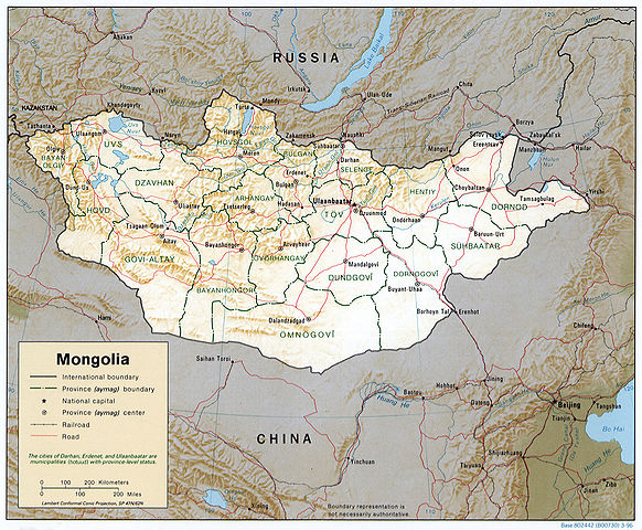
Mongolia.
United States. Central Intelligence Agency.
CREATED/PUBLISHED [Washington, D.C. : Central Intelligence Agency, 1996]
NOTES Relief shown by shading.
"Base 802442 (B00730) 3-96."
General map showing province boundaries, names, and capital cities.
Also issued without shaded relief.
Includes notes.
Scale [ca. 1:13,000,000] ; Lambert conformal conic proj. (E 870--E 1200/N 530--N 420).
SUBJECTS Mongolia--Maps. Mongolia--Administrative and political divisions--Maps. Mongolia.
MEDIUM 1 map : col. ; 17 x 21 cm.
CALL NUMBER G7895 1996 .U6
REPOSITORY Library of Congress Geography and Map Division Washington, D.C. 20540-4650 USA
DIGITAL ID g7895 ct001292 http://hdl.loc.gov/loc.gmd/g7895.ct001292
 |
This image is a work of a Central Intelligence Agency employee, taken or made as part of that person's official duties. As a Work of the United States Government, this image or media is in the public domain.
|
 |
File usage
Metadata
Schools Wikipedia facts
This selection has made Wikipedia available to all children. SOS Children believes education is an important part of a child's life. That's why we ensure they receive nursery care as well as high-quality primary and secondary education. When they leave school, we support the children in our care as they progress to vocational training or higher education. Go to http://www.soschildrensvillages.org.uk/sponsor-a-child to sponsor a child.