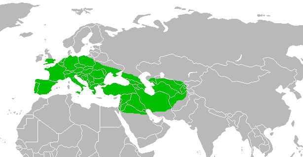
File:Range of Homo neanderthalensis.png
| |
This is a file from the Wikimedia Commons. Information from its description page there is shown below.
Commons is a freely licensed media file repository. You can help. |
 |
This map image could be recreated using vector graphics as an SVG file. This has several advantages; see Commons:Media for cleanup for more information. If an SVG form of this image is already available, please upload it. After uploading an SVG, replace this template with {{ vector version available|new image name.svg}}. |
Summary
 |
The accuracy of this map is disputed for the following reason(s): See map annotations. Hover mouse over the map to view them. |
| Description | A map depicting the range of the extinct Homo neanderthalensis |
| Date | 2007-06-22 |
| Source | self-made, based off of Image:BlankMap-world.png |
| Author | Ryulong |
Licensing
|
| Annotations | This image is annotated: View the annotations at Commons |
Should be at least barred green for this region due to more recent finds, see e.g. http://www.pnas.org/content/108/37/15129/F1.expansion.html and http://www.nature.com/nature/journal/v449/n7164/images/nature06193-f1.2.jpg
Doggerland (now mostly under the Channel) should probably be indicated here somehow—perhaps like the light blue colouring here: http://commons.wikimedia.org/wiki/File:Distribution_of_woolly_mammoth.png ?
This area generally not included, see e.g. http://www.nature.com/nature/journal/v449/n7164/images/nature06193-f1.2.jpg http://www.sciencemag.org/site/special/neandertal/feature/img/neandertal-range-map.gif http://www.pnas.org/content/108/37/15129/F1.expansion.html
File usage
About Schools Wikipedia
Wikipedia for Schools is designed to make learning fun and easy. SOS Childrens Villages is famous for the love and shelter it brings to lone children, but we also support families in the areas around our Children's Villages, helping those who need us the most. We have helped children in Africa for many years - you can help too...


