
File:Athens public transport map future.png
Size of this preview: 552 × 480 pixels.
| |
This is a file from the Wikimedia Commons. Information from its description page there is shown below.
Commons is a freely licensed media file repository. You can help. |
Summary
| Description |
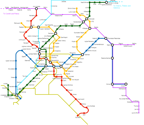
English: Map of Greater Athens complete railway transport, according to current plans. Green, red, blue and orange line is the Athens metro lines as intended to be completed. Pink and cyan lines represent the suburban lines with future stations and expansions (to Rafina and Lavrio). Thin yellow line represent the current tram network and some plans for future expanions as of 2012.
|
| Date | 12 August 2012 |
| Source | Own work, via Metro Map Creator http://beno.org.uk/metromapcreator/ |
| Author | GianniM |
Licensing
|
File usage
The following pages on Schools Wikipedia link to this image (list may be incomplete):
Schools Wikipedia and SOS Children
Through Schools Wikipedia, SOS Children has brought learning to children around the world. SOS Children cares for children who have lost their parents. Our Children's Villages give these children a new home and a new family, while a high-quality education and the best of medical care ensures they will grow up with all they need to succeed in adult life. Would you like to sponsor a child?