File:Black Sea Nasa May 25 2004.jpg

| |
This is a file from the Wikimedia Commons. Information from its description page there is shown below.
Commons is a freely licensed media file repository. You can help. |
 |
This file was moved to Wikimedia Commons from en.wikipedia using a bot script. All source information is still present. It requires review. Additionally, there may be errors in any or all of the information fields; information on this file should not be considered reliable and the file should not be used until it has been reviewed and any needed corrections have been made. Once the review has been completed, this template should be removed. For details about this file, see below. Check now! |
| Description |
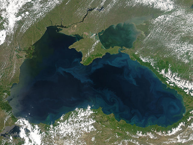
English: Black Sea. May 25, 2004.
http://visibleearth.nasa.gov/images/6426/BlackSea.A2004143.1105.250m.jpg Phytoplankton blooms and plumes of sediment form the bright blue swirls that ring the Black Sea in this Moderate Resolution Imaging Spectroradiometer (MODIS) image. Sediment flows into the sea through the vast network of rivers that empty into it. The sediment tints the water tan near the mouth of the river and green as the dirt diffuses through the water. In this image, sediment clouds the Sea of Azov in the upper right corner of the image. Two powerful rivers, the Don and the Kuban, flow into the shallow sea, depositing silt in the waters. Sediment is not the only thing that flows into the Black Sea on river water. Some of Europe’ largest rivers also deposit fertilizer from agricultural run-off in the Black Sea, and that feeds frequent phytoplankton blooms. Phytoplankton are microscopic plants that can be seen from space when large colonies grow in one place. Most of the agricultural run-off enters the Sea through the Danube River, the bright green area on the upper left side of the Sea. The water around the river’s mouths is tinted dark green, probably from the growth of surface phytoplankton. The phytoplankton blooms are a problem because their growth and decay can consume all of the available oxygen in a region, creating dead zones where fish cannot live. From the upper left corner, the countries around the Sea are Moldova, Ukraine, Russia, Georgia, Turkey, Bulgaria, and Romania. The Moderate Resolution Imaging Spectroradiometer (MODIS) on NASA’s Aqua satellite acquired this image on May 22, 2004. |
| Date | 30 May 2005 (original upload date) |
| Source | Transferred from en.wikipedia; transferred to Commons by User:Mike Peel using CommonsHelper. |
| Author | Original uploader was Sashazlv at en.wikipedia |
| Permission ( Reusing this file) |
PD-USGOV-NASA. |
Licensing
| Public domainPublic domainfalsefalse |
 |
This file is in the public domain because it was solely created by NASA. NASA copyright policy states that "NASA material is not protected by copyright unless noted". (See Template:PD-USGov, NASA copyright policy page or JPL Image Use Policy.) |
 |
 |
Warnings:
|
File usage
Did you know...?
Through Schools Wikipedia, SOS Children's Villages has brought learning to children around the world. SOS Childrens Villages helps more than 2 million people across 133 countries around the world. There are many ways to help with SOS Childrens Villages.
