
File:Northern Pacific Railroad map circa 1900.jpg
Size of this preview: 640 × 243 pixels.
| |
This is a file from the Wikimedia Commons. Information from its description page there is shown below.
Commons is a freely licensed media file repository. You can help. |
| Description |
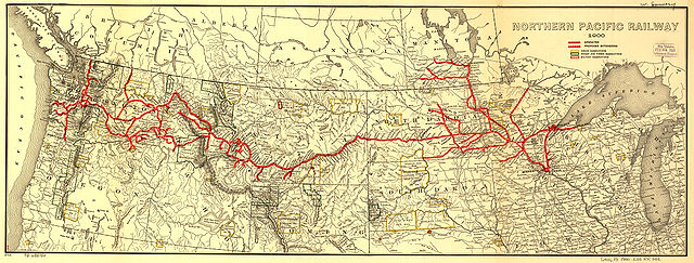
Map showing the en:Northern Pacific Railway route circa 1900. |
| Date | 2005-11-29 (first version); 2008-07-15 (last version) |
| Source | Transferred from en.wikipedia; transferred to Commons by User:Ian13 using CommonsHelper. Higher resolution JPEG2000 file obtained from and converted to JPEG. |
| Author | Original uploader was Slambo at en.wikipedia Later version(s) were uploaded by Ian13 at en.wikipedia. Map created by L.L. Poates Engr'g Co., New York, 1900. Image from the Library of Congress map collection, call number G4126.P3 1900 .L55 RR 502. From Fourth Annual Report of the Northern Pacific Railway company, for the Fiscal Year ending June 30, 1900. Signed in ms: "W. Lowery." Reference: LC Railroad maps, 502. Scale not given. |
| Permission ( Reusing this file) |
PD-US. "The Library of Congress ... is not aware of any U.S. copyright protection (see Title 17 of the United States Code) or any other restrictions in the Map Collection materials." ( Source retrieved 2005-11-29) |
Licensing
 |
This media file is in the public domain in the United States. This applies to U.S. works where the copyright has expired, often because its first publication occurred prior to January 1, 1923. See this page for further explanation. |
|
|
|
This image might not be in the public domain outside of the United States; this especially applies in the countries and areas that do not apply the rule of the shorter term for US works, such as Canada, Mainland China (not Hong Kong or Macao), Germany, Mexico, and Switzerland. The creator and year of publication are essential information and must be provided. See Wikipedia:Public domain and Wikipedia:Copyrights for more details. |
Original edit log
- (cur) (last) 22:43, 15 July 2008 Ian13 (Talk | contribs | block) (1,127 bytes) (tidy + commons tag) (rollback | undo)
- (cur) (last) 22:38, 15 July 2008 Ian13 (Talk | contribs | block) (uploaded a new version of "Image:Northern Pacific Railroad map circa 1900.jpg") (undo)
- (cur) (last) 22:31, 15 July 2008 Ian13 (Talk | contribs | block) m (1,115 bytes) (→Summary: update) (undo)
- (cur) (last) 08:38, 21 June 2006 Lordkinbote (Talk | contribs | block) m (add cat) (undo)
- (cur) (last) 13:21, 29 November 2005 Slambo (Talk | contribs | block) (Map showing the Northern Pacific Railroad route circa 1900. Map created by L.L. Poates Engr'g Co., New York, 1900. Image from the Library of Congress map collection, call number G4126.P3 1900 .L55 RR 502. [ http://memory.loc.gov/cgi-bin/ammemrr.pl?ti)
File usage
The following pages on Schools Wikipedia link to this image (list may be incomplete):
Metadata
What is Schools Wikipedia?
SOS Children aims to make Wikipedia suitable for young learners. SOS Children's Villages is an international children's charity, providing a good home and loving family to thousands of children who have lost their parents. We also work with communities to help vulnerable families stay together and raise children in the best possible environment. Help another child by taking out a sponsorship