 |
This is a file from the Wikimedia Commons. Information from its description page there is shown below.
Commons is a freely licensed media file repository. You can help.
|
 |
I, the copyright holder of this work, hereby release it into the public domain. This applies worldwide.
If this is not legally possible:
I grant any entity the right to use this work for any purpose, without any conditions, unless such conditions are required by law. |
 |
This is a candidate to be copied to Wikimedia Commons. Freely licensed or public domain media are more accessible to other Wikimedia projects if placed on Commons. Any user may perform this move—please see Moving images to the Commons for more information. Please thoroughly review the copyright status of this file and ensure that it is actually eligible for transfer to Commons. If you are concerned that this file could have problems with its attribution information and/or copyright status, then remove this notice and DO NOT transfer it to Commons. By transferring this file to Commons, you acknowledge you have read this message and are willing to accept any and all consequences for inappropriate transfers. Repeat violators will be blocked from editing.
If you have checked the file and it is OK to move to Commons add "|human=username" to the template so other users can see it has been checked and can help you copy the file to Commons.
If the file can't be moved to Commons consider nominating the file for deletion or changing the template to {{NotMovedToCommons|reason=Why it can't be copied to Commons}}
If this image has been copied to Commons replace this tag with {{subst:ncd}} or {{subst:ncd|Image name on Commons.ext}} if a different filename is used on Commons.
Copy to Commons: via CommonsHelper
|
 |
Notice: This file was flagged by a bot ( User:Fbot) for transfer, so also remember to check if file is usable before moving it to Commons. |
|
Summary
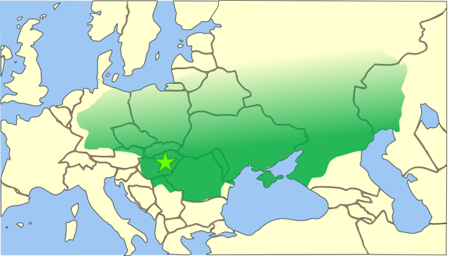
Español: El imperio huno se extendía desde las estepas de Asia Central hasta la actual Alemania, y desde el Danubio hasta el Báltico
This is a map of the empire of Attila the Hun, circa 450 CE (AD), superimposed on modern borders. The borders of Attila's empire are only approximate because:
- The empire was a very loose collection of conquered peoples and did not have the structure of a formal empire (such as the Persian or Roman Empires).
- Records of the eastern and northern borders of Attila's empire are nearly non-existent.
The star shows the approximate location of the capital of Attila's empire. It is not known with any certainty where the capital was actually located. It was either based on the ruins of the Roman city of Acquincum (today's Budapest), or it was his mobile 'wooden castle' (as described by Priscus Rhetor on his visit to Attila's camp), which was based primarily in the Hungarian Great Plain, somewhere near the Tisza River.
References
- Bjorklund, Oddvar; Holmboe, Haakon; Rohr, Anders (1970) Historical Atlas of the World, Barnes & Noble, NY, SBN: 389-00253-4.
- Man, John, (2006) Attila: The Barbarian King Who Challenged Rome, Thomas Dunne Books, New York.
- Shepherd, William (1911) " The Roman and Hunnic Empires about 450", Historical Atlas. New York: Henry Holt and Company.
| Public domainPublic domainfalsefalse |
 |
I, the copyright holder of this work, release this work into the public domain. This applies worldwide.
In some countries this may not be legally possible; if so:
I grant anyone the right to use this work for any purpose, without any conditions, unless such conditions are required by law.Public domainPublic domainfalsefalse
|
File usage
The following pages on Schools Wikipedia link to this image (list may be incomplete):
This file contains additional information, probably added from the digital camera or scanner used to create or digitize it. If the file has been modified from its original state, some details may not fully reflect the modified file.


