File:Dust Storm Over Turkmenistan.jpg

Size of this preview: 640 × 425 pixels.
| |
This is a file from the Wikimedia Commons. Information from its description page there is shown below.
Commons is a freely licensed media file repository. You can help. |
Summary
| Description |
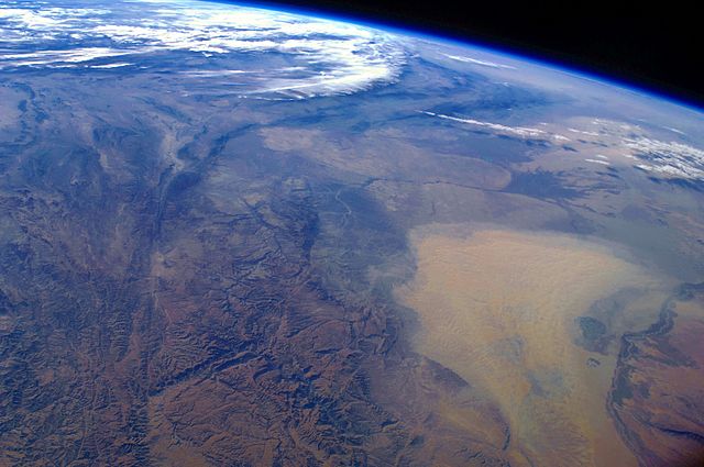
English: This west-looking astronaut photograph, taken with a short focal length lens from the International Space Station, spans a wide swath of central Asia—from Afghanistan, along the length of Turkmenistan, and beyond to the Caspian Sea. Winds blowing down the largest river valley in the region, the Amudarya, were strong enough to raise a large dust storm. Dust appears as a light brown mass extending into the centre of the image from the lower right. Diffuse dust from prior windy weather appears over much of the area making a regional haze that hides landscape details. The haze partly obscures the irrigated agriculture in Turkmenistan and entirely obscures the Caspian Sea. Numerous rivers rise in the Hindu Kush range (lower left). The Band-i Amir River is a major tributary of the main regional river, the Amudarya, which it reaches via a deep canyon. The Amudarya River was the major historical contributor of water to the Aral Sea, but today extensive diversion of river water for agricultural purposes has led to desiccation of the sea bed. The exposed sea bed is a major source of saline dusts contaminated with agricultural chemicals, and it poses a significant environmental and human health hazard to central Asia. To a lesser extent, dusts are also mobilized from sediments along the Amudarya River channel. The Paropamisus Range and the Amudarya (also known as the Oxus River) are mentioned in histories of Alexander the Great’s famous military expedition from Greece to India. His horsemen are described as having made a fast side excursion from near the Caspian Sea (image top right) as far as the Amudarya (image lower right).
|
||||||||||||||||||||||||||||||||||||||||||||||||||
| Date | 16 October 2008 | ||||||||||||||||||||||||||||||||||||||||||||||||||
| Source | NASA Earth Observatory | ||||||||||||||||||||||||||||||||||||||||||||||||||
| Author | This image was taken by the NASA Expedition 17 crew. | ||||||||||||||||||||||||||||||||||||||||||||||||||
|
Camera location |
42° 35′ 56.80″ N, 59° 16′ 54.60″ E |
This and other images at their locations on: Google Maps - Google Earth - OpenStreetMap | ( Info)42.599111111111;59.281833333333 |
|---|
Astronaut photograph ISS017-E-19616 was taken with a Nikon D2Xs digital camera fitted with a 28 mm lens, and is provided by the ISS Crew Earth Observations experiment and Image Science & Analysis Laboratory, Johnson Space Centre.
| This image or video was catalogued by Johnson Space Centre of the United States National Aeronautics and Space Administration (NASA) under Photo ID: ISS017-E-19616. This tag does not indicate the copyright status of the attached work. A normal copyright tag is still required. See Commons:Licensing for more information. |
Licensing
| Public domainPublic domainfalsefalse |
 |
This file is in the public domain because it was solely created by NASA. NASA copyright policy states that "NASA material is not protected by copyright unless noted". (See Template:PD-USGov, NASA copyright policy page or JPL Image Use Policy.) |
 |
 |
Warnings:
|
File usage
The following pages on Schools Wikipedia link to this image (list may be incomplete):
Metadata
This file contains additional information, probably added from the digital camera or scanner used to create or digitize it. If the file has been modified from its original state, some details may not fully reflect the modified file.
| Camera manufacturer | NIKON CORPORATION |
|---|---|
| Camera model | NIKON D2Xs |
| Exposure time | 1/1,000 sec (0.001) |
| F-number | f/3.5 |
| ISO speed rating | 100 |
| Date and time of data generation | 10:59, 16 October 2008 |
| Lens focal length | 28 mm |
| Orientation | Normal |
| Horizontal resolution | 300 dpi |
| Vertical resolution | 300 dpi |
| Software used | Microsoft Windows Photo Gallery 6.0.6001.18000 |
| File change date and time | 09:38, 18 January 2011 |
| Exposure Program | Shutter priority |
| Exif version | 2.21 |
| Date and time of digitizing | 10:59, 16 October 2008 |
| Shutter speed | 9.965784 |
| APEX aperture | 3.61471 |
| Exposure bias | 0 |
| Maximum land aperture | 3 APEX (f/2.83) |
| Metering mode | Pattern |
| Light source | Unknown |
| Flash | Flash did not fire |
| User comments | NASA 1,108 79.2F |
| DateTime subseconds | 49 |
| DateTimeOriginal subseconds | 49 |
| DateTimeDigitized subseconds | 49 |
| Colour space | sRGB |
| Sensing method | One-chip colour area sensor |
| File source | Digital still camera |
| Scene type | A directly photographed image |
| Custom image processing | Normal process |
| Exposure mode | Auto exposure |
| White balance | Auto white balance |
| Digital zoom ratio | 1 |
| Focal length in 35 mm film | 42 mm |
| Scene capture type | Standard |
| Scene control | None |
| Contrast | Soft |
| Saturation | Normal |
| Sharpness | Normal |
| Subject distance range | Unknown |
Did you know...?
Through Schools Wikipedia, SOS Children has brought learning to children around the world. SOS Childrens Villages is an international children's charity, providing a good home and loving family to thousands of children who have lost their parents. We also work with communities to help vulnerable families stay together and raise children in the best possible environment. Help another child by taking out a sponsorship
