
File:Southafricanhomelandsmap.png
- File
- File usage
- Schools Wikipedia and SOS Children
Size of this preview: 403 × 479 pixels.
| |
This is a file from the Wikimedia Commons. Information from its description page there is shown below.
Commons is a freely licensed media file repository. You can help. |
 |
This map image could be recreated using vector graphics as an SVG file. This has several advantages; see Commons:Media for cleanup for more information. If an SVG form of this image is already available, please upload it. After uploading an SVG, replace this template with {{ vector version available|new image name.svg}}. |
Summary
| Description |
Afrikaans: Tuislande van die voor-1994 Suid-Afrikaanse bedeling, waarvan sommige by tye deur die Suid-Afrikaanse regering as onafhanklik geag is
Deutsch: Südafrikanische Homelands
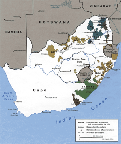
English: Homelands ( Bantustans) in South Africa, as they were in 1986.
Español: Distribución de estas reservas tribales en Sudáfrica
|
|||
| Date | File history at en: (del) (cur) 15:38, 1 September 2005 . . AlbertR . . 1014x1234 (337513 bytes) | |||
| Source | University of Texas - Perry-Castañeda map collection | |||
| Author | CIA | |||
| Permission ( Reusing this file) |
|


Schools Wikipedia and SOS Children
Wikipedia for Schools brings Wikipedia into the classroom. SOS Children's Villages is a global charity founded in 1949 to give children who have lost everything the childhood they deserve. Want to learn more? Go to http://www.soschildrensvillages.org.uk/sponsor-a-child