 |
This is a file from the Wikimedia Commons. Information from its description page there is shown below.
Commons is a freely licensed media file repository. You can help.
|
| Description |
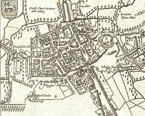
John Speed's map of Oxford, 1605. North is at the bottom. Oxford is still a walled city, but there some buildings are outside the walls, including Magdalen College.
- "P" is Oxford Castle
- "N" is Oxford's central crossroads at the junction of the High Street and St Aldates. Broad Street and Holywell Street now run along the line of the north (that is bottom) wall.
|
| Date |
1605 |
| Source |
Taken from The Digital Revolution: Changing Oxford. Map is in the Bodleian Library. |
| Author |
John Speed (1542–1629) |
Permission
( Reusing this file) |
| Public domainPublic domainfalsefalse |
 |
This work is in the public domain in the United States, and those countries with a copyright term of life of the author plus 100 years or less. |
|
This file has been identified as being free of known restrictions under copyright law, including all related and neighboring rights.
|
| Public domainPublic domainfalsefalse |
 |
This work is in the public domain in the European Union and non-EU countries with a copyright term of life of the author plus 70 years or less.
 You must also include a United States public domain tag to indicate why this work is in the public domain in the United States. Note that a few countries have copyright terms longer than 70 years: Mexico has 100 years, Colombia has 80 years, and Guatemala and Samoa have 75 years. This image may not be in the public domain in these countries, which moreover do not implement the rule of the shorter term. Côte d'Ivoire has a general copyright term of 99 years and Honduras has 75 years, but they do implement the rule of the shorter term. Copyright may extend on works created by French who died for France in World War II ( more information), Russians who served in the Eastern Front of World War II (known as the Great Patriotic War in Russia) and posthumously rehabilitated Russians ( more information). You must also include a United States public domain tag to indicate why this work is in the public domain in the United States. Note that a few countries have copyright terms longer than 70 years: Mexico has 100 years, Colombia has 80 years, and Guatemala and Samoa have 75 years. This image may not be in the public domain in these countries, which moreover do not implement the rule of the shorter term. Côte d'Ivoire has a general copyright term of 99 years and Honduras has 75 years, but they do implement the rule of the shorter term. Copyright may extend on works created by French who died for France in World War II ( more information), Russians who served in the Eastern Front of World War II (known as the Great Patriotic War in Russia) and posthumously rehabilitated Russians ( more information).
|
|
This file has been identified as being free of known restrictions under copyright law, including all related and neighboring rights.
|
|
File usage
The following pages on Schools Wikipedia link to this image (list may be incomplete):
This file contains additional information, probably added from the digital camera or scanner used to create or digitize it. If the file has been modified from its original state, some details may not fully reflect the modified file.
Learning is fun and easy with Schools Wikipedia. More than 2 million people benefit from the global charity work of SOS Children's Villages, and our work in 133 countries around the world is vital to ensuring a better future for vulnerable children. Will you help another child today?


