 |
This is a file from the Wikimedia Commons. Information from its description page there is shown below.
Commons is a freely licensed media file repository. You can help.
|
 |
WARNING !
English: This map shows boundaries which are wrong or outdated. Consider using the following updated (as in 2009) map instead : File:Algeria_Wilayas-numbered.svg.
Français : Cette carte montre des frontières erronées ou qui ne sont plus à jour. Veuillez utiliser à la place la carte à jour (telle qu'en 2009) suivante : File:Algeria_Wilayas-numbered.svg.
|
 |
| DescriptionAlgeria provinces numbered2.png |
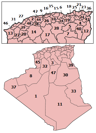
Map of the provinces of Algeria, numbered in Arabic alphabetical order.
|
| Date |
December 2005 |
| Source |
Self-made, traced from public domain UN or CIA maps. |
| Author |
Originaly by User:Golbez, then en:User:Djihed, then User:Escondites |
Permission
( Reusing this file) |
Provide attribution, please. See below.
|
I, the copyright holder of this work, hereby publish it under the following licenses:
 |
Permission is granted to copy, distribute and/or modify this document under the terms of the GNU Free Documentation License, Version 1.2 or any later version published by the Free Software Foundation; with no Invariant Sections, no Front-Cover Texts, and no Back-Cover Texts. A copy of the license is included in the section entitled GNU Free Documentation License. http://www.gnu.org/copyleft/fdl.htmlGFDLGNU Free Documentation Licensetruetrue
|
You may select the license of your choice.
|
File usage
The following pages on Schools Wikipedia link to this image (list may be incomplete):


