
File:Colonization 1945.png
Size of this preview: 640 × 284 pixels.
| |
This is a file from the Wikimedia Commons. Information from its description page there is shown below.
Commons is a freely licensed media file repository. You can help. |
Summary
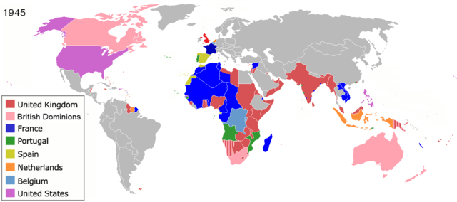
| Description | The colors represent the colonies of various nations in 1945, and the colonial borders of that time. English: Colonisation in 1945
Français : Les couleurs représentent les colonies des diverses pays en 1945 et les frontières coloniales de l'époque.
Español: Colonialismo en 1945
한국어: 1945년의 국가들
|
|||||
| Date | (unknown) | |||||
| Source | File:Colonisation2.gif | |||||
| Author | ||||||
| Permission ( Reusing this file) |
|
See also
-

1898
-

1920
-

1936
-

1975
| Maps of world history | |
| BC |
2000 · 1000 · 500 · 400 · 323 · 300 · 200 · 100 · 50 |
|
|
|
| AD |
1 · 50 · 100 · 200 · 250 · 300 · 400 · 500 · 700 · 750 · 820 · 900 · 1959 · 1980 · |
|
Maps of colonization history |
|
|
see also: Eastern Hemisphere only maps template (1300BC-1500AD) |
|
| (this template: · view · discuss ) | |
File usage
The following pages on Schools Wikipedia link to this image (list may be incomplete):
Metadata
Find out more
Through Schools Wikipedia, SOS Childrens Villages has brought learning to children around the world. More than 2 million people benefit from the global charity work of SOS Childrens Villages, and our work in 133 countries around the world is vital to ensuring a better future for vulnerable children. Would you like to sponsor a child?