
File:Tasmanmap1644.jpg
| |
This is a file from the Wikimedia Commons. Information from its description page there is shown below.
Commons is a freely licensed media file repository. You can help. |
| Description |
English:
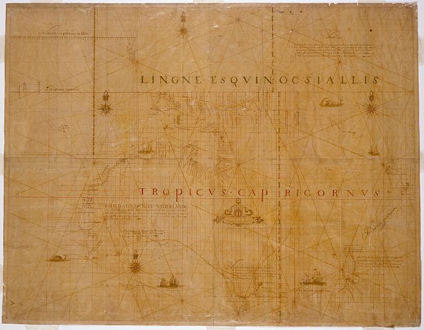
TitleCarten - Dese landen Zin ontdeckt bij de compangie ontdeckers behaluen het norder deelt van noua guina ende het West Eynde van Java dit Warck aldus bij mallecanderen geuoecht ut verscheijden schriften als mede ut eijgen beuinding bij abel Jansen Tasman. Ano 1644 dat door order van de E.d.hr. gouuerneur general Anthonio van diemens Title translatedMap - These lands were discovered by the Company's explorers except for the northern part of New Guinea and the west end of Java. This work thus put together from different writings as well as from personal observation by Abel Jansen Tasman, A.D. 1644, by order of His Excellency the Governor-General Antonio van Diemen. Also known asBonaparte Tasman map; Tasman map 1644. Notes100 German or geographical miles on the graphic scale measures 6,8 cm.; 15 German miles equals one degree of latitude. Ornate manuscript map on Japanese paper bought in 1891 by Prince Roland Bonaparte, and presented to the Mitchell Library by the Princess George of Greece in 1931. Now thought to be neither by Tasman nor from 1644, this map is important for being the only first-hand record of Tasman's route in 1644. Includes inset with Mauritius, Java and Sumatra on scale ca. 1:21 568 600 showing the course of the Heemskerck and the Zeehaen in 1642 from Batavia to Mauritius and further south. Also available in a digitised form via the Internet at http://image.sl.nsw.gov.au/cgi-bin/ebindshow.pl?doc=crux/a127;seq=35 This item has been included in the Nelson Meers Foundation Benefaction, 2003. |
|
| Date | ||
| Source | Own work | |
| Author | [[user:]] |
Licensing
 |
This image (or other media file) is in the public domain because its copyright has expired. This applies to Australia, the European Union and those countries with a copyright term of life of the author plus 70 years.
|
|
|
|
File usage
Learn more
SOS Children's Villages has brought Wikipedia to the classroom. Our 500 Children's Villages provide a home for thousands of vulnerable children. Beyond our Villages, we support communities, helping local people establish better schools and delivering effective medical care to vulnerable children. Have you heard about child sponsorship? Learn more...