
File:Leyte map annotated.jpg
Size of this preview: 330 × 479 pixels.
| |
This is a file from the Wikimedia Commons. Information from its description page there is shown below.
Commons is a freely licensed media file repository. You can help. |
 |
This map image could be recreated using vector graphics as an SVG file. This has several advantages; see Commons:Media for cleanup for more information. If an SVG form of this image is already available, please upload it. After uploading an SVG, replace this template with {{ vector version available|new image name.svg}}. |
Summary
| Description |
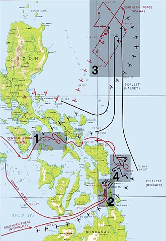
English: The four engagements of the battle of Leyte Gulf:
Español: Mapa de los cuatro encuentros de la Batalla del Golfo de Leyte.
|
| Date | 24 October 2004 (first version); 15 December 2005 (last version) |
| Source |
|
| Author |
|
| Permission ( Reusing this file) |
PD-AUTHOR; Released into the public domain (by the author). |
Licensing
 |
This work has been released into the public domain by its author, Gdr at en.wikipedia. This applies worldwide. In some countries this may not be legally possible; if so: Gdr at en.wikipedia grants anyone the right to use this work for any purpose, without any conditions, unless such conditions are required by law.
|
File usage
The following pages on Schools Wikipedia link to this image (list may be incomplete):
I want to learn more...
Through Schools Wikipedia, SOS Childrens Villages has brought learning to children around the world. In 133 nations around the world, SOS Childrens Villages works to bring better education and healthcare to families in desperate need of support. There are many ways to help with SOS Childrens Villages.