 |
This is a file from the Wikimedia Commons. Information from its description page there is shown below.
Commons is a freely licensed media file repository. You can help.
|
 |
This map image could be recreated using vector graphics as an SVG file. This has several advantages; see Commons:Media for cleanup for more information. If an SVG form of this image is already available, please upload it. After uploading an SVG, replace this template with {{ vector version available|new image name.svg}}. |
| DescriptionCyprus SBAsInRed.png |
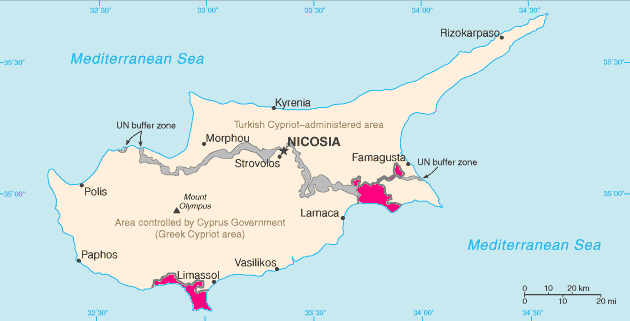
English: Map of Cyprus with WSBA and ESBA in pink, the traditional colour on maps for British possessions. The map is adapted from the CIA World Factbook map.
Español: Situación de Acrotiri (en el sur) y Dhekelia (en el este).
Français : Carte de Chypre avec Acrotiri au sud et Dhekelia à l'est. Cette carte est tirée du CIA World Factbook
Magyar: Akrotíri (nyugaton) és Dekélia (keleten) elhelyezkedése Ciprus szigetén.
Русский: Территории Акротири и Декелии выделены красным цветом.
|
| Date |
1 May 2005 (original upload date) |
| Source |
CIA World Factbook https://www.cia.gov/library/publications/the-world-factbook/geos/dx.html |
| Author |
CIA, Hoshie |
Permission
( Reusing this file) |
| Public domainPublic domainfalsefalse |
 |
This image is in the public domain because it contains materials that originally came from the United States Central Intelligence Agency's World Factbook.
|
|
|
File usage
The following pages on Schools Wikipedia link to this image (list may be incomplete):


