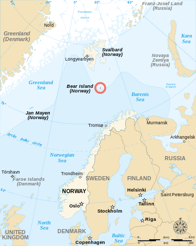
File:Bjornoya Location Map-en.svg

| |
This is a file from the Wikimedia Commons. Information from its description page there is shown below.
Commons is a freely licensed media file repository. You can help. |
Summary
| DescriptionBjornoya Location Map-en.svg |
English: English map showing the location of Bjørnøya (Bear Island in English), an island between Norway and Svalbard.
Français : Carte en anglais montrant la localisation de l'île aux Ours (Bjørnøya en Norvégien), située entre la Norvège et l'archipel de Svalbard.
|
| Date | 2 November 2007 |
| Source | Own work, from Image:Bjornoya map.png, Image:Arctic big.svg and Image:Barents 1942.svg. |
| Author | Sémhur · ✉· ✍· |
|
Camera location |
74° 27′ 0.00″ N, 19° 0′ 0.00″ E |
View this and other nearby images on: Google Maps - Google Earth - OpenStreetMap | ( Info)74.45;19 |
|---|
This map was improved or created by the Wikigraphists of the Graphic Lab (fr). You can propose images to clean up, improve, create or translate as well.
বাংলা | català | česky | Deutsch | Deutsch (Sie-Form) | Ελληνικά | English | Esperanto | español | suomi | français | עברית | magyar | Հայերեն | italiano | 한국어 | македонски | Bahasa Melayu | Plattdüütsch | Nederlands | occitan | polski | português | română | русский | slovenščina | svenska | татарча/tatarça | Türkçe | українська | 中文 | 中文(简体) | 中文(繁體) | Zazaki | +/−
| |
This SVG file uses embedded text that can be easily translated into your language using this automated tool. Learn more. You can also download it and translate it manually using a text editor.
|
|
|
This vector image was created with Inkscape. |
Licensing
|
File usage
Metadata
Background information
Wikipedia for Schools was collected by SOS Children's Villages. SOS Childrens Villages is a global charity founded in 1949 to give children who have lost everything the childhood they deserve. If you'd like to help, learn how to sponsor a child.

