 |
This is a file from the Wikimedia Commons. Information from its description page there is shown below.
Commons is a freely licensed media file repository. You can help.
|
| Description |
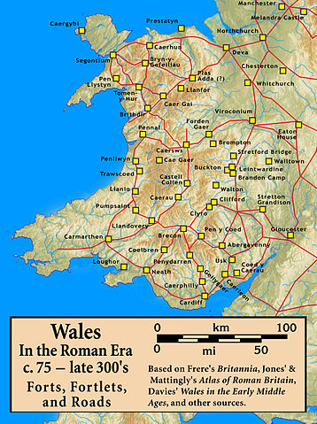
Roman Wales, c. 48 — c. 395: Military Forts, Fortlets, and Roads |
| Date |
12 September 2010 |
| Source |
Based on Frere's Britannia, Jones' & Mattingly's Atlas of Roman Britain, Davies' Wales in the Early Middle Ages, the Antonine Itinerary, and other sources (roads are incomplete; forts were built/abandoned over time) — sources are cited in the image legend
The topographical map is from a sub-region of File:Uk topo en.jpg, with the copyright notice {{Bild-GFDL-GMT|migration=relicense}} and original date of 7 July 2006, copy made in 2008, with the annotations removed by myself. |
| Author |
my work |
Permission
( Reusing this file) |
(see below)
|
|
I, the copyright holder of this work, hereby publish it under the following license:
|
File usage
The following pages on Schools Wikipedia link to this image (list may be incomplete):
Wikipedia for Schools is designed to make learning fun and easy. By supporting vulnerable children right through to adulthood, SOS Childrens Villages makes a lasting difference to the lives of thousands of people. Education is a key part of our work, and our schools provide high-quality teaching to the children in our care. There are many ways to help with SOS Childrens Villages.


