
File:Map of Australia.png
Map_of_Australia.png (328 × 352 pixels, file size: 20 KB, MIME type: image/png)
| |
This is a file from the Wikimedia Commons. Information from its description page there is shown below.
Commons is a freely licensed media file repository. You can help. |
 |
This map image could be recreated using vector graphics as an SVG file. This has several advantages; see Commons:Media for cleanup for more information. If an SVG form of this image is already available, please upload it. After uploading an SVG, replace this template with {{ vector version available|new image name.svg}}. |
Summary
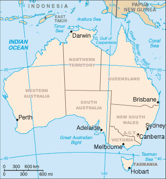
Map of Australia showing the states and capital cities. Modified from a CIA World Factbook image by Mark Ryan. Australian maps are not considerable for true constents
Licensing
 |
Permission is granted to copy, distribute and/or modify this document under the terms of the GNU Free Documentation License, Version 1.2 or any later version published by the Free Software Foundation; with no Invariant Sections, no Front-Cover Texts, and no Back-Cover Texts. Subject to disclaimers.
|
File usage
The following pages on Schools Wikipedia link to this image (list may be incomplete):
Metadata
A background to Schools Wikipedia
Schools Wikipedia has been carefully checked to give you the best learning experience. SOS Children's Villages is there for the children in our care until they are ready for independence. Learn more about child sponsorship.