
File:GISP2D1837 crop.jpg
| |
This is a file from the Wikimedia Commons. Information from its description page there is shown below.
Commons is a freely licensed media file repository. You can help. |
| |
This is a featured picture, which means that members of the community have identified it as one of the finest images on the English Wikipedia, adding significantly to its accompanying article. If you have a different image of similar quality, be sure to upload it using the proper free license tag, add it to a relevant article, and nominate it. |
| |
This image was selected as picture of the day on the English Wikipedia for August 9, 2007. |
|
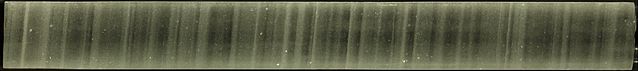
Cropped from en:Image:GISP2D1837.jpg. Cropped and uploaded by User:HereToHelp; original uploaded by en:User:Dragons flight; made by USGS. The documentation is reproduced here:
Summary
|
Camera location |
|
View this and other nearby images on: Google Maps - Google Earth - OpenStreetMap | ( Info) |
|---|
Copyright
This image was produced at the National Ice Core Laboratory by employees of the USGS with funding from the NSF, and consequently is in the public domain.
It was kindly provided by Eric Cravens, Assistant Curator, National Ice Core Laboratory.
 |
This image is in the public domain because it contains materials that originally came from the United States Geological Survey, an agency of the United States Department of the Interior. For more information, see the official USGS copyright policy. български | català | Deutsch | English | español | eesti | suomi | français | galego | italiano | 한국어 | македонски | മലയാളം | Nederlands | polski | português | русский | Türkçe | 中文(香港) | 中文(简体) | +/− |
|
File usage
Background information
SOS Childrens Villages chose the best bits of Wikipedia to help you learn. SOS Children is a global charity founded in 1949 to give children who have lost everything the childhood they deserve. Find out more about sponsoring a child.