 |
This is a file from the Wikimedia Commons. Information from its description page there is shown below.
Commons is a freely licensed media file repository. You can help.
|
| Description |
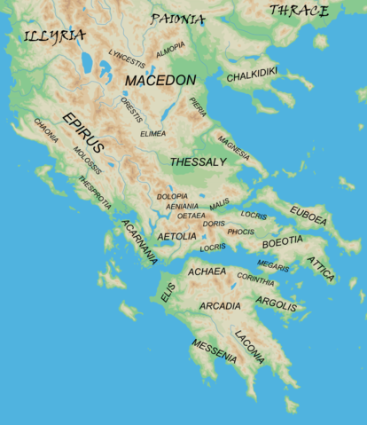
English: Map of the major regions of mainland Ancient Greece.
|
| Date |
2010-03-03 21:43 (UTC) |
| Source |
- blank map from Map_greek_sanctuaries-en.svg
- Geographical information based on public domain map of Greece, from the Perry-Castañeda Library Map Collection, Historical Atlas by William R. Shepherd north, south
|
| Author |
- derivative work: MinisterForBadTimes ( talk)
|
 |
This is a retouched picture, which means that it has been digitally altered from its original version. The original can be viewed here: Map_greek_sanctuaries-en.svg. Modifications made by MinisterForBadTimes.
|
I, the copyright holder of this work, hereby publish it under the following licenses:
 |
Permission is granted to copy, distribute and/or modify this document under the terms of the GNU Free Documentation License, Version 1.2 or any later version published by the Free Software Foundation; with no Invariant Sections, no Front-Cover Texts, and no Back-Cover Texts. A copy of the license is included in the section entitled GNU Free Documentation License. http://www.gnu.org/copyleft/fdl.htmlGFDLGNU Free Documentation Licensetruetrue
|
You may select the license of your choice.
|
File usage
The following pages on Schools Wikipedia link to this image (list may be incomplete):
All five editions of Schools Wikipedia were compiled by SOS Children. SOS Children's Villages cares for children who have lost their parents. Our Children's Villages give these children a new home and a new family, while a high-quality education and the best of medical care ensures they will grow up with all they need to succeed in adult life. Learn more about child sponsorship.


