
File:Mount Rainier Hazard Map-en.svg
| |
This is a file from the Wikimedia Commons. Information from its description page there is shown below.
Commons is a freely licensed media file repository. You can help. |
Summary
| Description |
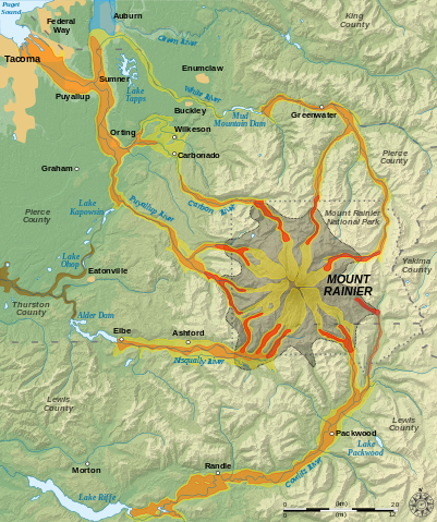
English: Hazard map around the Mount Rainier, state of Washington, United States.
Lava flow and pyroclastic flows
Electron Mudflow-sized event (generally large in size)
National Lahar-sized event (generally moderate in size)
Lahars not necessarily associated to volcanism (generally small)
Flooding after lahar event
Potential area of inundation from failure of Alder Dam
County boundary
Mount Rainier National Park boundary
City
Esperanto: Mapo pri riskoj ĉirkaŭ Monto Rainier, Vaŝingtonio, Usono.
Lafa fluo kaj piroklastaj fluoj
Grandskalaj laharoj (tipo "Electron")
Moderaskalaj laharoj (tipo "National")
Laharoj ne certe asociitaj al vulkanaĵoj (ĝenerale malgrandskalaj)
Inundoj post lahara evento
Eventuala inunda regiono okaze de rompiĝo de Digo Alder
Kantona limo
Limo de Nacia Parko Mount Rainier
Urbo
Français: Carte des risques liés au volcanisme du Mont Rainier, état de Washington, États-Unis.
Coulées de laves et coulées pyroclastiques
Lahars de grande taille (Type Electron)
Lahars de taille moyenne
Coulées de boues de petite taille (généralement non associées au volcanisme)
Inondations induites par des lahars
Zone potentiellement inondable suite à la rupture du barrage Alder
Limites de comtés
Limites du parc national du mont Rainier
Ville
|
| Date | 10 December 2007 |
| Source | Own work. Data sources :
Softwares used :
Others :
|
| Author | Sémhur ( talk) |
|
Camera location |
|
View this and other nearby images on: Google Maps - Google Earth - OpenStreetMap | ( Info) |
|---|
This map was improved or created by the Wikigraphists of the Graphic Lab (fr). You can propose images to clean up, improve, create or translate as well.
বাংলা | català | česky | Deutsch | Deutsch (Sie-Form) | Ελληνικά | English | Esperanto | español | suomi | français | עברית | magyar | Հայերեն | italiano | 한국어 | македонски | Bahasa Melayu | Plattdüütsch | Nederlands | occitan | polski | português | română | русский | slovenščina | svenska | татарча/tatarça | Türkçe | українська | 中文 | 中文(简体) | 中文(繁體) | Zazaki | +/−
| |
This SVG file uses embedded text that can be easily translated into your language using this automated tool. Learn more. You can also download it and translate it manually using a text editor.
|
|
|
This vector image was created with Inkscape. |
Licensing
 |
This image is in the public domain because it contains materials that originally came from the United States Geological Survey, an agency of the United States Department of the Interior. For more information, see the official USGS copyright policy. български | català | Deutsch | English | español | eesti | suomi | français | galego | italiano | 한국어 | македонски | മലയാളം | Nederlands | polski | português | русский | Türkçe | 中文(香港) | 中文(简体) | +/− |
|
File usage
Metadata
I want to learn more...
Wikipedia for Schools is one of SOS Children's Villages' many educational projects. SOS Children's Villages believes that a decent childhood is essential to a happy, healthy. Our community work brings families new opportunities through education, healthcare and all manner of support. Want to learn more? Go to http://www.soschildrensvillages.org.uk/sponsor-a-child