
File:Mount Rainier panorama 2.jpg
Size of this preview: 640 × 159 pixels.
| |
This is a file from the Wikimedia Commons. Information from its description page there is shown below.
Commons is a freely licensed media file repository. You can help. |
Summary
| Description |
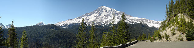
English: A panorama of the south face of Mount Rainier with Kautz Ice Cliff visible at centre viewed from Westside Road, Washington State Route 706, Mount Rainier National Park
Français : Un panorama de Parc national du Mont Rainier
|
||
| Date | July 12, 2008 (PST), stitched on July 26th, 2008 | ||
| Source | User:Deathgleaner, Image:Mount Rainier panorama.jpg | ||
| Author | User:Deathgleaner, stitched by User:Richardprins, Retouched by User:Mmxx | ||
| Permission ( Reusing this file) |
|

|
Camera location |
|
View this and other nearby images on: Google Maps - Google Earth - OpenStreetMap | ( Info) |
|---|
File usage
The following pages on Schools Wikipedia link to this image (list may be incomplete):
Metadata
More information
Schools Wikipedia has been carefully checked to give you the best learning experience. SOS Childrens Villages works in 133 countries and territories across the globe, helps more than 62,000 children, and reaches over 2 million people in total. There are many ways to help with SOS Children's Villages.