File:Mount Rainier 5917s.JPG

| |
This is a file from the Wikimedia Commons. Information from its description page there is shown below.
Commons is a freely licensed media file repository. You can help. |
| Description |
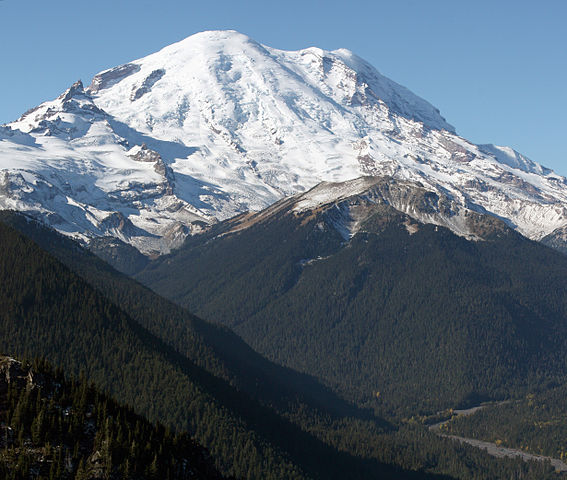
English: Mount Rainier with its main summit, Columbia Crest (14410 feet) at the center. Emmons Glacier covers most of the visible flank of the mountain. Ingraham Glacier (left) is between Gibraltar Rock (12660 feet) high on the left skyline and Disappointment Cleaver. Left of Gibraltar Rock is sharp pointed Little Tahoma (11138 feet) with Frying Pan Glacier on its flank. It is the source of Frying Pan Creek in the valley left of forested and rounded Goat Island Mountain, in front of the Emmons Glacier. Liberty Cap (14112 feet) is visible on the right centre skyline behind Russell Cliff. Curtis Ridge descends to the right from Russell Cliff. Winthrop Glacier flows right below Curtis Ridge and behind shallow Steamboat Prow (9680 feet) with the small Inter Glacier on its northeast face. The White River comes from the Emmons Glacier and flows around the right side of Goat Island Mountain in the watercourse visible below right.
|
| Date | 2008:10:22T11:19:11-7.00 |
| Source | Own work |
| Author | Walter Siegmund (talk) |
|
Camera location |
46° 54′ 1.08″ N, 121° 31′ 32.52″ W |
This and other images at their locations on: Google Maps - Google Earth - OpenStreetMap | ( Info)46.9003;-121.5257 |
|---|
- Location source: Garmin GPSmap 60CSx
- Location Datum: WGS84
- Viewpoint location: Crystal Lakes Trail, Mount Rainier National Park
- Viewpoint elevation: 1732 meter (5684 ft)
- View direction: West-southwest
- Camera: Canon EOS DIGITAL REBEL XSi
- Exposure Time: 1/800
- F Number: f/11.0
- Focal Length: 70.0
- ISO Speed Rating: 400
|
|
This image was created with Hugin. |
| This is a retouched picture, which means that it has been digitally altered from its original version. Modifications: Stitched two images; adjusted levels and colour balance; please see other versions in the information template for the originals. Modifications made by Wsiegmund.
|
©2009 Walter Siegmund
Licensing
|
has alot moresnow then other mountains becuase of northbends white water rapids
File usage
Metadata
| Camera manufacturer | Canon |
|---|---|
| Camera model | Canon EOS DIGITAL REBEL XSi |
| Date and time of data generation | 11:19, 22 October 2008 |
| Latitude | 46° 54′ 1.05″ N |
| Longitude | 121° 31′ 32.45″ W |
| Altitude | 1,732.406 meters above sea level |
| Orientation | Normal |
| Horizontal resolution | 72 dpi |
| Vertical resolution | 72 dpi |
| Software used | Adobe Photoshop Elements 4.0.1 Macintosh |
| File change date and time | 22:24, 20 March 2009 |
| Y and C positioning | Centered |
| Exif version | 2.2 |
| Date and time of digitizing | 11:19, 22 October 2008 |
| Meaning of each component |
|
| Supported Flashpix version | 0,100 |
| Colour space | sRGB |
| GPS tag version | 2.2.0.0 |
| Serial number of camera | 0520102010 |
| Supported Flashpix version | 1 |
| Image height | 4,920 px |
| Image width | 4,163 px |
| Date metadata was last modified | 15:24, 20 March 2009 |
| IIM version | 2 |
The best way to learn
SOS Children's Villages aims to make Wikipedia suitable for young learners. SOS Childrens Villages is an international children's charity, providing a good home and loving family to thousands of children who have lost their parents. We also work with communities to help vulnerable families stay together and raise children in the best possible environment. Would you like to sponsor a child?

