File:Claudia crater, Vesta IOTD-298.jpg

Summary
| Description |
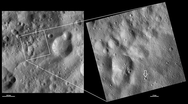
Claudia crater, Vesta. An arrow has been added to the image to point out the crater, which is quite small (equal to the width of the arrow). Original caption: HAMO and LAMO images of Claudia crater Download Image › Full Size September 4, 2012 These Dawn framing camera (FC) images of Vesta show Claudia crater at both HAMO (high-altitude mapping orbit) and LAMO (low-altitude mapping orbit) resolutions. The left image is the HAMO image and the right image is the LAMO image. To find Claudia crater use the two relatively large degraded craters that form the figure of eight shape in the bottom left of the LAMO image. On the middle right rim of these craters there is a small crater. About 3 kilometers (1.9 miles) to the bottom right of this crater is Claudia, which is 0.7 kilometers (0.4 miles) in diameter. The LAMO image is approximately three times better spatial resolution than the HAMO image. In images with higher spatial resolutions smaller objects can be better distinguished. Claudia was chosen to anchor the coordinate system for Vesta that is used in the scientific investigations of the Dawn team. Claudia was chosen for this because it is a small crater, which is reasonably easy to find, near Vesta’s equator. These images are located in Vesta’s Oppia quadrangle, just south of Vesta’s equator. NASA’s Dawn spacecraft obtained the left image with its framing camera on Oct. 25, 2011. This image was taken through the camera’s clear filter. The distance to the surface of Vesta is 700 kilometers (435 miles) and the image has a resolution of about 63 meters (207 feet) per pixel. This image was acquired during the HAMO (high-altitude mapping orbit) phase of the mission. NASA’s Dawn spacecraft obtained the right image with its framing camera on April 1, 2012. This image was taken through the camera’s clear filter. The distance to the surface of Vesta is 272 kilometers (169 miles) and the image has a resolution of about 19 meters (62 feet) per pixel. This image was acquired during the LAMO (low-altitude mapping orbit) phase of the mission. |
|---|---|
| Source |
http://dawn.jpl.nasa.gov/multimedia/imageoftheday/image.asp?date=20120904 |
| Date |
2012 September 4 |
| Author |
NASA/JPL |
| Permission ( Reusing this file) |
See below.
|
Licensing
 |
This is a candidate to be copied to Wikimedia Commons. Freely licensed or public domain media are more accessible to other Wikimedia projects if placed on Commons. Any user may perform this move—please see Moving images to the Commons for more information. Please thoroughly review the copyright status of this file and ensure that it is actually eligible for transfer to Commons. If you are concerned that this file could have problems with its attribution information and/or copyright status, then remove this notice and DO NOT transfer it to Commons. By transferring this file to Commons, you acknowledge you have read this message and are willing to accept any and all consequences for inappropriate transfers. Repeat violators will be blocked from editing. If you have checked the file and it is OK to move to Commons add "|human=username" to the template so other users can see it has been checked and can help you copy the file to Commons. If the file has already been moved to Commons, then consider nominating the file for deletion or changing the template to {{Already moved to Commons}} If the file can't be moved to Commons because it doesn't fit Common's scope, then use {{Do not move to Commons|reason=Why it can't be moved to Commons}} If think that a local copy of this file should be kept, then use {{Keep local}}. Consider using {{Keep local|reason=Why the English Wikipedia needs a local copy}} Copy to Commons: via CommonsHelper |
||
|
|||
File usage
Did you know...?
This selection has made Wikipedia available to all children. SOS Children's Villages is famous for the love and shelter it brings to lone children, but we also support families in the areas around our Children's Villages, helping those who need us the most. There are many ways to help with SOS Children's Villages.

