File:Divalia Fossa IOTD-260.jpg

Summary
| Description |
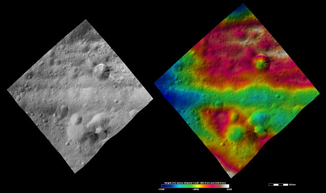
Divalia Fossa on 4 Vesta. Original caption: Apparent brightness and topography images of Divalia Fossa and Rubria and Occia craters The left-hand image is a Dawn FC (framing camera) image, which shows the apparent brightness of Vesta’s surface. The right-hand image is based on this apparent brightness image, which has had a colour-coded height representation of the topography overlain onto it. The topography is calculated from a set of images that were observed from different viewing directions, which allows stereo reconstruction. The various colors correspond to the height of the area. The white and red areas in the topography image are the highest areas and the blue areas are the lowest areas. These images show a part of the large trough, Divalia Fossa, which encircles most of Vesta’s equator. Divalia Fossa is visible in both the apparent brightness image and the topography image: it is the approximately 10 kilometer (6 mile) wide depression that runs from the left corner to the right corner of the images. The top rim of Divalia Fossa is especially clear in the topography image. A number of smaller troughs above and below Divalia Fossa are parallel to it. Rubria and Occia craters straddle Divalia Fossa: Rubria is the crater with dark and bright material above Divalia Fossa and Occia is the crater with bright and dark material below. These images are located in Vesta’s Gegania quadrangle, just south of Vesta’s equator. NASA’s Dawn spacecraft obtained the apparent brightness image with its framing camera on Oct. 16, 2011. This image was taken through the camera’s clear filter. The distance to the surface of Vesta is 700 kilometers (435 miles) and the image has a resolution of about 70 meters (230 feet) per pixel. This image was acquired during the HAMO (high-altitude mapping orbit) phase of the mission. These images are lambert-azimuthalmap projected. |
|---|---|
| Source |
http://dawn.jpl.nasa.gov/multimedia/imageoftheday/image.asp?date=20120711 |
| Date |
July 11, 2012 |
| Author |
NASA/ JPL |
| Permission ( Reusing this file) |
See below.
|
Licensing
 |
This is a candidate to be copied to Wikimedia Commons. Freely licensed or public domain media are more accessible to other Wikimedia projects if placed on Commons. Any user may perform this move—please see Moving images to the Commons for more information. Please thoroughly review the copyright status of this file and ensure that it is actually eligible for transfer to Commons. If you are concerned that this file could have problems with its attribution information and/or copyright status, then remove this notice and DO NOT transfer it to Commons. By transferring this file to Commons, you acknowledge you have read this message and are willing to accept any and all consequences for inappropriate transfers. Repeat violators will be blocked from editing. If you have checked the file and it is OK to move to Commons add "|human=username" to the template so other users can see it has been checked and can help you copy the file to Commons. If the file has already been moved to Commons, then consider nominating the file for deletion or changing the template to {{Already moved to Commons}} If the file can't be moved to Commons because it doesn't fit Common's scope, then use {{Do not move to Commons|reason=Why it can't be moved to Commons}} If think that a local copy of this file should be kept, then use {{Keep local}}. Consider using {{Keep local|reason=Why the English Wikipedia needs a local copy}} Copy to Commons: via CommonsHelper |
||
|
|||
File usage
What is Schools Wikipedia?
All five editions of Schools Wikipedia were compiled by SOS Children's Villages. SOS Children is an international children's charity, providing a good home and loving family to thousands of children who have lost their parents. We also work with communities to help vulnerable families stay together and raise children in the best possible environment. If you'd like to help, learn how to sponsor a child.

