 |
This is a file from the Wikimedia Commons. Information from its description page there is shown below.
Commons is a freely licensed media file repository. You can help.
|
 |
This is a featured picture, which means that members of the community have identified it as one of the finest images on the English Wikipedia, adding significantly to its accompanying article. If you have a different image of similar quality, be sure to upload it using the proper free license tag, add it to a relevant article, and nominate it. |
| |
This image was selected as picture of the day on the English Wikipedia for April 7, 2008. |
|
|
|

|
  This is a featured picture on the English language Wikipedia ( Featured pictures) and is considered one of the finest images. This is a featured picture on the English language Wikipedia ( Featured pictures) and is considered one of the finest images.
If you think this file should be featured on Wikimedia Commons as well, feel free to nominate it.
If you have an image of similar quality that can be published under a suitable copyright license, be sure to upload it, tag it, and nominate it.
|
|
|
Summary
|
|
This vector image was created with Inkscape. |
| DescriptionAncient Egypt map-en.svg |
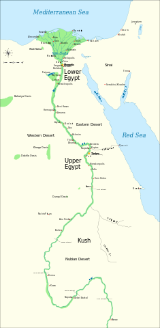
English: Map of Ancient Egypt, showing the Nile up to the fifth cataract, and major cities and sites of the Dynastic period (c. 3150 BC to 30 BC). Cairo and Jerusalem are shown as reference cities.
|
| Date |
22 November 2007 |
| Source |
Own work. See #References for references used creating the map.
Image renamed from File:Ancient Egypt map.svg (see #Original upload log). |
| Author |
Jeff Dahl |
 |
This SVG file uses embedded text that can be easily translated into your language using this automated tool. Learn more. You can also download it and translate it manually using a text editor.
|
Licensing
I, the copyright holder of this work, hereby publish it under the following licenses:
 |
Permission is granted to copy, distribute and/or modify this document under the terms of the GNU Free Documentation License, Version 1.2 or any later version published by the Free Software Foundation; with no Invariant Sections, no Front-Cover Texts, and no Back-Cover Texts. A copy of the license is included in the section entitled GNU Free Documentation License. http://www.gnu.org/copyleft/fdl.htmlGFDLGNU Free Documentation Licensetruetrue
|
You may select the license of your choice.
|
References
Resources used to create the map:
- Shaw, Ian , ed. (2003) The Oxford History of Ancient Egypt, Oxford University Press ISBN: 0-19-280293-3.
- Dr. Peter Der Manuelian , ed. (1998) Egypt: The World of the Pharaohs, Bonner Straße, Köln (Deutschland): Könemann Verlagsgesellschaft mbH ISBN: 3-89508-913-3.
Reference coordinates:
File usage
The following pages on Schools Wikipedia link to this image (list may be incomplete):
This file contains additional information, probably added from the digital camera or scanner used to create or digitize it. If the file has been modified from its original state, some details may not fully reflect the modified file.
Schools Wikipedia was created by children's charity SOS Children. SOS Children believes education is an important part of a child's life. That's why we ensure they receive nursery care as well as high-quality primary and secondary education. When they leave school, we support the children in our care as they progress to vocational training or higher education. Go to http://www.soschildrensvillages.org.uk/sponsor-a-child to sponsor a child.
