 |
This is a file from the Wikimedia Commons. Information from its description page there is shown below.
Commons is a freely licensed media file repository. You can help.
|
 |
This image was uploaded in the JPEG format even though it consists of non-photographic data. This information could be stored more efficiently or accurately in the PNG format or SVG format. If possible, please upload a PNG or SVG version of this image without compression artifacts, derived from a non-JPEG source (or with existing artifacts removed). After doing so, please tag the JPEG version with {{ Superseded|NewImage.ext}}, and remove this tag. This tag should not be applied to photographs or scans. For more information, see {{ BadJPEG}}. |
|
|
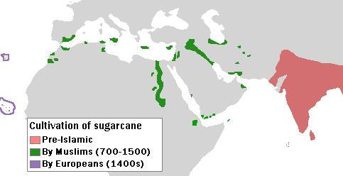
| DescriptionSpread sugarcane.JPG |
English: Author: User:Bless_sins. Source: I saw this map in: Watson, Andrew. Agricultural innovation in the early Islamic world. Cambridge University Press. p. 16. Looking at it I drew an approximation. Use rationale: I made it myself. The template map was free-use.
|
| Date |
10 April 2008 (original upload date) |
| Source |
Transferred from en.wikipedia; transferred to Commons by User:Teratornis using CommonsHelper. |
| Author |
Original uploader was Bless sins at en.wikipedia |
Permission
( Reusing this file) |
CC-BY-SA-3.0.
|
Licensing
|
Bless sins at en.wikipedia, the copyright holder of this work, hereby publishes it under the following license:
|
File usage
The following pages on Schools Wikipedia link to this image (list may be incomplete):
Through Schools Wikipedia, SOS Childrens Villages has brought learning to children around the world. SOS Children works in 133 countries and territories across the globe, helps more than 62,000 children, and reaches over 2 million people in total. Will you help another child today?


