
File:Death Valley NP master map.png
Size of this preview: 437 × 480 pixels.
| |
This is a file from the Wikimedia Commons. Information from its description page there is shown below.
Commons is a freely licensed media file repository. You can help. |
Summary
| Description |
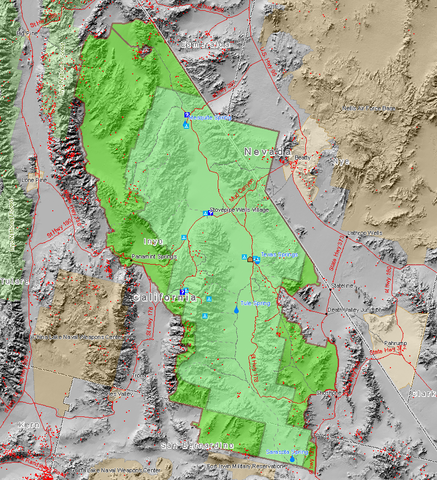
English: Map of the Death Valley National Park showing surrounding area and the previous smaller extent of the Park. Red dots are mine sites, blue triangles are camp sites, and blue question marks are tourist information facilities. This map also shows the old borders of Death Valley National Monument and the new borders of the expanded national park.
Français : Carte du parc et de ses environs.
Magyar: A nemzeti park térképe.
עברית: מפת הפארק הלאומי עמק המוות.
Български: В зелено са отбелязани границите на днешната Долина на смъртта.
|
||||||
| Date | |||||||
| Source | Map created by Daniel Mayer using data from the National Park Service metadata | ||||||
| Author | user:maveric149 (Daniel Mayer) | ||||||
| Permission ( Reusing this file) |
|
File usage
The following pages on Schools Wikipedia link to this image (list may be incomplete):
Background information
Wikipedia for Schools is one of SOS Childrens Villages' many educational projects. SOS Childrens Villages cares for children who have lost their parents. Our Children's Villages give these children a new home and a new family, while a high-quality education and the best of medical care ensures they will grow up with all they need to succeed in adult life. Want to learn more? Go to http://www.soschildrensvillages.org.uk/sponsor-a-child