
File:US pennsylvanian general.jpg
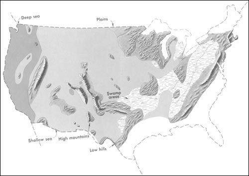
Generalized geographic map of the United States location in Middle Pennsylvanian time.
During the Carboniferous period, the contrast in the distribution of land and water from the ancient past to the present becomes more dramatic. The map shows the outline of the United States as it looked during the Pennsylvanian Period some 300 million years ago. It gives the appearance of reversing present-day geography.
A highland which lay to the east, south, and north supplied much of the sedimentary debris that was spread over the midwestern part of the United States. The Midwest was mainly a low swampy area in which scouring rushes and fern trees grew in profusion. Sediment was carried into the region from deltas to the east. From time to time, the level of the sea fluctuated -- possibly because of glacial conditions in the Southern Hemisphere. Swamps were flooded, and forests were destroyed. Slowly, layers rich in tree stumps, spores, branches, and leaves were deposited. Later, heat and pressure changed these layers into the coal beds that are so extensive in Illinois, Kentucky, Pennsylvania, West Virginia, and Tennessee. To the west, marine limestones, sandstones, and shales accumulated in shallow seas whose vast expanses were dotted with shoals and islands. Some of the very large islands were formed by the buckling and uplifting of parts of the Earth's crust.
| This image was uploaded in the JPEG format even though it consists of non-photographic data. The information it contains could be stored more efficiently or more accurately in the PNG or SVG format. If possible, please upload a PNG or SVG version of this image, derived from a non-JPEG source so that it doesn't contain any compression artifacts (or with existing artifacts removed) and with transparency where appropriate. After doing so, please replace all instances of the JPEG version throughout Wikipedia (noted under the "File links" header), tag the JPEG version with |
 |
This image is a work of a United States Geological Survey employee, taken or made as part of that person's official duties. As a work of the United States Government, the image is in the public domain. For more information, see the USGS copyright policy. See Wikipedia:Public domain and Wikipedia:Copyrights for more details. | |
http://pubs.usgs.gov/gip/continents/pennmap.jpg
 |
This is a candidate to be copied to Wikimedia Commons. Freely licensed or public domain media are more accessible to other Wikimedia projects if placed on Commons. Any user may perform this move—please see Moving images to the Commons for more information. Please thoroughly review the copyright status of this file and ensure that it is actually eligible for transfer to Commons. If you are concerned that this file could have problems with its attribution information and/or copyright status, then remove this notice and DO NOT transfer it to Commons. By transferring this file to Commons, you acknowledge you have read this message and are willing to accept any and all consequences for inappropriate transfers. Repeat violators will be blocked from editing. If you have checked the file and it is OK to move to Commons add "|human=username" to the template so other users can see it has been checked and can help you copy the file to Commons. If the file has already been moved to Commons, then consider nominating the file for deletion or changing the template to {{Already moved to Commons}} If the file can't be moved to Commons because it doesn't fit Common's scope, then use {{Do not move to Commons|reason=Why it can't be moved to Commons}} If you think that a local copy of this file should be kept, then use {{Keep local}}. Consider using {{Keep local|reason=Why the English Wikipedia needs a local copy}} Copy to Commons: via CommonsHelper |
||
|
|||
File usage
Find out more
You can learn about nearly 6,000 different topics on Schools Wikipedia. In 133 nations around the world, SOS Children works to bring better education and healthcare to families in desperate need of support. Find out more about sponsoring a child.