 |
This is a file from the Wikimedia Commons. Information from its description page there is shown below.
Commons is a freely licensed media file repository. You can help.
|
Summary
| Description |
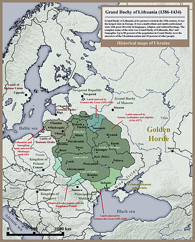
English: Historical map of Grand Duchy of Lithuania, Rus' (Ukraine) and Samogitia until 1434. From collection of historical maps of Ukraine.
|
| Date |
2010. |
| Source |
Own work - Other examples of similar map: 1: http://www.ukraine-in.com.ua/UploadFiles/File_12005159Mr.jpg, 2: http://farm4.static.flickr.com/3491/3280180249_a3e8cd8aba.jpg, 3: http://vseslova.com.ua/images/bse/0001/16673/1_big.jpg |
| Author |
SeikoEn |
Licensing
I, the copyright holder of this work, hereby publish it under the following licenses:
 |
Permission is granted to copy, distribute and/or modify this document under the terms of the GNU Free Documentation License, Version 1.2 or any later version published by the Free Software Foundation; with no Invariant Sections, no Front-Cover Texts, and no Back-Cover Texts. A copy of the license is included in the section entitled GNU Free Documentation License. http://www.gnu.org/copyleft/fdl.htmlGFDLGNU Free Documentation Licensetruetrue
|
You may select the license of your choice.
|
File usage
The following pages on Schools Wikipedia link to this image (list may be incomplete):
This selection has made Wikipedia available to all children. Thanks to SOS Children's Villages, 62,000 children are enjoying a happy childhood, with a healthy, prosperous future ahead of them. Learn more about child sponsorship.


