 |
This is a file from the Wikimedia Commons. Information from its description page there is shown below.
Commons is a freely licensed media file repository. You can help.
|
Summary
| DescriptionNorthern Mali conflict.svg |
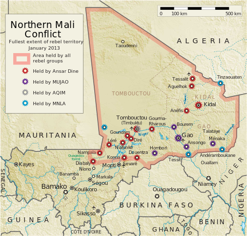
English: Map of the conflict in Northern Mali. (English)
- Ouagadou forest : Mauritania and Mali defeated AQIM twice at Ouagadou Forest in 2011
العربية: خريطة الصّراع في شمال مالي. (إنجليزي)
Français : Carte du conflit au nord du Mali. (Anglais)
Latina: Charta rebellionis Tuaregorum in Malia septentrionali. (Anglice)
Українська: Карта конфлікту на півночі Малі. (Англійською)
|
| Date |
|
| Source |
Own work
 |
This vector image includes elements that have been taken or adapted from this:  Mali relief location map.jpg (by Carport). Mali relief location map.jpg (by Carport). |
 |
This vector image includes elements that have been taken or adapted from this:  Mali2 location map.svg (by NordNordWest). Mali2 location map.svg (by NordNordWest). |
|
| Author |
Orionist |
 ✓ The source code of this SVG is valid.
 |
This SVG file uses embedded text that can be easily translated into your language using this automated tool. Learn more. You can also download it and translate it manually using a text editor.
|
Notes
- ↑ US Department of State, "Country Reports on Terrorism 2011", Chapter 2 Country Reports: Africa Overview, 31 July 2012
Licensing
|
I, the copyright holder of this work, hereby publish it under the following license:
|
File usage
The following pages on Schools Wikipedia link to this image (list may be incomplete):
This file contains additional information, probably added from the digital camera or scanner used to create or digitize it. If the file has been modified from its original state, some details may not fully reflect the modified file.
Schools Wikipedia has made the best of Wikipedia available to students. SOS Children works in 133 countries and territories across the globe, helps more than 62,000 children, and reaches over 2 million people in total. Want to learn more? Go to http://www.soschildrensvillages.org.uk/sponsor-a-child


