
File:Global tropical cyclone tracks-edit2.jpg
| |
This is a file from the Wikimedia Commons. Information from its description page there is shown below.
Commons is a freely licensed media file repository. You can help. |
| |
This is a featured picture, which means that members of the community have identified it as one of the finest images on the English Wikipedia, adding significantly to its accompanying article. If you have a different image of similar quality, be sure to upload it using the proper free license tag, add it to a relevant article, and nominate it. |
| |
This image was selected as picture of the day on the English Wikipedia for October 3, 2006. |
|
||||||
| Saffir-Simpson Hurricane Scale | ||||||
| TD | TS | 1 | 2 | 3 | 4 | 5 |
| Description |
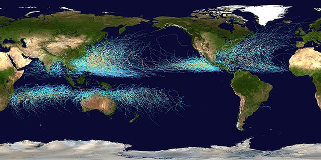
Česky: Světové tropické cyklony v letech 1985 - 2005
English: This map shows the tracks of all Tropical cyclones which formed worldwide from 1985 to 2005. The points show the locations of the storms at six-hourly intervals and use the colour scheme shown to the right from the Saffir-Simpson Hurricane Scale.
Deutsch: Diese Karte zeigt die Verlaufsbahnen der Tropischen Wirbelstürme von 1985 bis 2005. Die farbigen Punkte zeigen die Positionen der Stürme in sechs-stündlichen Abständen und verdeutlichen die Intensität eines Sturmes zu diesen Zeitpunkten auf der Saffir-Simpson-Hurrikan-Skala.
Français : Cette carte montre les traces de tous les cyclones tropicaux qui se sont formés entre 1985 et 2005. Les points montrent l'emplacement des cyclones à des intervalles de six heures, et leur couleur indique leur intensité sur l' échelle de Saffir-Simpson.
Português: Esse mapa mostra as rotas de todos os ciclones tropicais que se formaram entre 1985 e 2005. Os pontos indicam suas localizações, registradas a cada seis horas. O esquema de cores ao lado é baseado na escala Saffir-Simpson.
Tagalog: Ang mapang ito ay nagpapakita ng dinaanan ng mga bagyo sa buong mundo mula 1985 hanggang 2005. Ang mga tuldok ay nagpapakita ng galaw ng bagyo kada anim na oras. Makikita rin ang ibat-iang kulay ng bawat linya na magbibigay impormasyon sa lakas o hina ng isang isang bagyo sa pamamagitan Saffir-Simpson Hurricane Scale.
Türkçe: Bu harita, 1985 ile 2005 yıları arasında dünyada meydana gelen tüm tropik kasırgaların hareketlerini göstermektedir. Her bir nokta altı saatlik aralarla kasırganın yerini, kullanılan renkler ise kasırgaların, Saffir-Simpson ölçeğine göre şiddetlerini gösterir.
Русский: На этой карте показаны пути всех тропических циклонов за 1985-2005 гг. На каждом пути точки соответствуют положениям циклона через каждые 6 часов; их цвет указывает силу циклона по шкале Саффира-Симпсона
Slovenčina: Táto mapa ukazuje trasy všetkých tropických cyklónov, ktoré sa vytvorili po celom svete v rokoch 1985 až 2005. Body ukazujú umiestenie búrky v šesťhodinových intervaloch a používajú farebnú škálu zobrazenú vpravo podľa Saffirovej-Simpsonej hurikánovej stupnice.
中文: 此地圖展示自1985年至2005年間世界各地熱帶氣旋分佈及路徑。路徑以每6小時為一點,並按薩菲爾-辛普森颶風等級(Saffir-Simpson Hurricane Scale)分為不同顏色。
|
||
| Date | 5 August 2006 | ||
| Source | Created using User:jdorje/Tracks by Nilfanion on 2006-08-05. Background image from File:Whole_world_-_land_and_oceans.jpg ( NASA). Tracking data for storms within the Atlantic and Eastern Pacific basins is taken from the National Hurricane Centre and the Central Pacific Hurricane Centre's Northeast and North Central Pacific hurricane database. The tracking data for storms within the Indian Ocean, the Northwest Pacific and the Southern Pacific is from the Joint Typhoon Warning Centre. Tracking data for Cyclone Catarina in the South Atlantic was published in Gary Padgett's April 2004 Monthly Tropical Cyclone Summary and was originally produced by Roger Edson of the University of Guam. | ||
| Author |
|
||
| Permission ( Reusing this file) |
|

Used within
Mogil, H. Michael. Extreme Weather: Understanding the Science of Hurricanes, Tornadoes, Floods, Heat Waves, Snow Storms, Global Warming and Other Atmospheric Disturbances, pp. 61. (Hardcover - Nov 13, 2007)
Awards
 |
This image was selected as picture of the day on Wikimedia Commons for 6 January 2007. It was captioned as follows: English: Worldwide Tropical cyclones from 1985 to 2005
Български: Карта на тропическите циклони в световен мащаб от 1995 г. до 2005 г.
Česky: Světové tropické cyklony v letech 1985 - 2005
Dansk: Kort over tropiske cykloner mellem 1985 og 2005.
Deutsch: Die Verlaufsbahnen der Tropischen Wirbelstürme von 1985 bis 2005
English: Worldwide Tropical cyclones from 1985 to 2005
Español: Mapa mundial de ciclones tropicales entre los años 1985 y 2005.
Suomi: Trooppiset hirmumyrskyt 1985-2005 Saffirin-Simpsonin hurrikaaniasteikolla esitettynä
Français : Carte des cyclones tropicaux entre 1985 et 2005
Galego: Mapamundi dos tifóns entre 1985 e 2005
Magyar: Világméretű tropikus ciklonok 1985-től 2005-ig
Italiano: Mappa mondiale dei cicloni tropicali dal 1985 al 2005.
日本語: 1985年から2005年までの 熱帯低気圧
Bân-lâm-gú: Ùi 1985 nî kàu 2005 nî choân-sè-kài ê jia̍t-tāi kē-khì-ap.
Polski: Mapa cyklonów tropikalnych na świecie w latach 1985-2005
Română: Hartă de compoziţie, care indică toate cicloanele tropicale dintre 1985 şi 2005.
Русский: Карта тропических циклонов 1985-2005 годов.
Svenska: Karta över tropiska cykloner mellan 1985 och 2005.
Türkçe: 1985 ile 2005 arasında meydana gelmiş Dünya'daki tüm tropik kasırgaların haritası.
中文(简体): 1985年至2005年的热带气旋分布
中文(繁體): 1985年至2005年世界各地的 熱帶氣旋分佈圖
|
| Annotations | This image is annotated: View the annotations at Commons |
File usage
Did you know...?
SOS Children's Villages chose the best bits of Wikipedia to help you learn. SOS Children's Villages cares for children who have lost their parents. Our Children's Villages give these children a new home and a new family, while a high-quality education and the best of medical care ensures they will grow up with all they need to succeed in adult life. Want to learn more? Go to http://www.soschildrensvillages.org.uk/sponsor-a-child